Advertisement
)
AT A GLANCE
- Concept: Passive Detection: The sensors emit absolutely no radar energy, remaining mathematically invisible to the enemy they are tracking.
- Concept: Clock Synchronization: The entire system relies on atomic clocks linked by GPS to achieve nanosecond-level timing precision across vast distances.
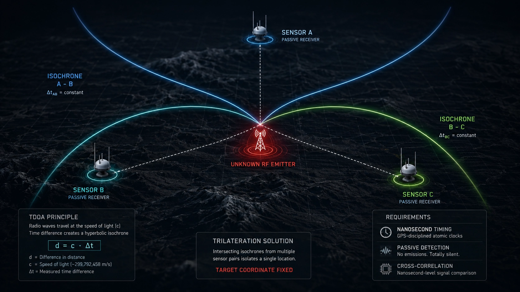
- Concept: Isochrone Mapping: The mathematical difference in signal arrival time creates a hyperbolic curve of possible locations on a digital map.
- Concept: Cross-Correlation: Intersecting three or more of these hyperbolic curves mathematically isolates the exact geographic coordinate of the transmitter.
HOW IT WORKS
Traditional radar operates like a flashlight in a dark room; it actively blasts energy out and looks for the reflection, instantly revealing the searcher’s own location. Modern Signals Intelligence (SIGINT) relies on total invisibility.
Time Difference of Arrival (TDOA) is a purely passive listening architecture. A military deploys a matrix of three or more receiver antennas, often mounted on drones, satellites, or mobile ground vehicles. These sensors simply listen to the ambient electromagnetic spectrum.
When an adversary turns on a radio, a radar dish, or a cell phone, it broadcasts a radio-frequency (RF) wave that travels outward at the speed of light. Because the listening sensors are physically separated, that single RF wave hits each sensor at a slightly different time.
The TDOA system does not care about the actual content of the intercepted message; it only cares about the timestamp. However, radio waves travel roughly one foot per nanosecond (a billionth of a second). To detect these minute differences, every sensor in the matrix must be perfectly synchronized using GPS-disciplined rubidium atomic clocks.
Once the sensors capture the timestamps, a central processor runs a mathematical cross-correlation. The time difference between Sensor A and Sensor B does not yield a single point; it creates a hyperbolic curve across a map known as an isochrone. Every point on that curve represents a location where the time difference is identical.
The equation governing this curve is based on the velocity of propagation:
$$d = c \cdot \Delta t$$
Where d is the difference in distance from the emitter to the two sensors, c is the speed of light, and Delta t is the measured time difference of arrival. By calculating the isochrone for Sensor A and B, and intersecting it with the isochrone generated by Sensor B and C, the math produces a single, highly precise geographic coordinate pinpointing the enemy emitter.
WHY IT MATTERS NOW
In a high-end geopolitical conflict, the electromagnetic spectrum is the absolute primary battlespace. If a military unit turns on an active transmitter, they reveal their location and invite immediate kinetic destruction.
This reality has forced global militaries into extreme emission control (EMCON). Adversaries utilize encrypted, low-probability-of-intercept burst transmissions that only last for microseconds. Traditional directional antennas, which physically spin to find the strongest signal, are far too slow to catch these transient digital bursts.
TDOA arrays solve this timing problem. Because the sensors are omnidirectional and constantly listening, they instantly catch microsecond bursts. A Russian mobile command post sending a split-second encrypted text message via a civilian 5G network provides enough electromagnetic energy for a TDOA matrix to triangulate its position to within ten meters.
Defense contractors like L3Harris and BAE Systems are actively miniaturizing these systems. By placing lightweight TDOA sensors on autonomous drone swarms, tactical commanders can cast a temporary, localized surveillance net over a specific battlefield. When an enemy sniper turns on a commercial walkie-talkie, the drone swarm instantly computes the coordinates and feeds them directly to automated artillery, completing the kill chain in seconds without ever emitting a single active radar ping.
WHAT MOST PEOPLE MISS
Intelligence analysis often treats geolocation as a perfect, autonomous digital function, assuming more sensors automatically equal better targeting. They miss the severe geometric constraints that govern the accuracy of the mathematical intersection.
This vulnerability is known as Geometric Dilution of Precision (GDOP). If the three listening sensors are flying in a straight line relative to the target, the hyperbolic curves will intersect at shallow, elongated angles. This creates a massive “ellipse of uncertainty” on the map, meaning the target could be anywhere within a several-mile radius.
To achieve weapons-grade targeting precision, the sensor matrix must physically surround the target to force the hyperbolic lines to cross at perpendicular, 90-degree angles. TDOA is not just a math problem; it is a rigid kinematic choreography. Pilots and drone operators must constantly maneuver their airframes into optimal, staggered geographic formations relative to the suspected enemy position before the software can actually generate a usable coordinate.
THE TRAJECTORY
Next 12–36 Months: Electronic warfare units will integrate TDOA algorithms directly with Frequency Difference of Arrival (FDOA) systems. By measuring the Doppler shift of the signal alongside the timing delay, aircraft will calculate the exact velocity and trajectory of moving emitters, tracking enemy mobile missile launchers in real-time.
Next Five Years: Low Earth Orbit (LEO) commercial satellite constellations will commercialize global TDOA surveillance. Private intelligence firms will map the global movement of shadow-fleet oil tankers by continuously triangulating the faint RF emissions from their automated navigation radars, entirely bypassing the need to hack their GPS transponders.
Next Ten Years: TDOA processing will transition from centralized cloud servers directly to the tactical edge. Sensor nodes will use federated machine learning chips to autonomously cross-correlate signal timing data locally, sharing only the final, weapon-ready coordinates across heavily degraded, low-bandwidth military networks.
What Could Go Wrong: The entire TDOA architecture is fundamentally anchored to the GPS timing signal. If an adversary successfully executes a localized GPS spoofing attack, they can artificially inject nanosecond timing errors into one of the listening sensors. This invisible disruption will wildly skew the hyperbolic calculations, tricking the algorithm into directing artillery fire at empty fields or civilian infrastructure.
Most Likely Outcome: Passive TDOA geolocation will entirely supersede active radar scanning for tactical ground targeting. The absolute necessity to remain electromagnetically invisible will force all modern militaries to rely exclusively on cross-correlated mathematical surveillance to locate the enemy before initiating kinetic strikes.
KEY TERMS
- Time Difference of Arrival (TDOA): A geolocation technique that triangulates a target by measuring the exact nanosecond a single radio wave hits multiple, dispersed sensors.
- Isochrone: A hyperbolic curve on a map connecting all geographic points where the time difference between two specific sensors is mathematically identical.
- Cross-Correlation: The statistical mathematical process of comparing two separate digital signals to determine exactly how far they are shifted in time relative to each other.
- Geometric Dilution of Precision (GDOP): The degradation in geolocation accuracy caused by the poor physical arrangement or alignment of the listening sensors relative to the target.
- Signals Intelligence (SIGINT): The gathering of intelligence by the interception and analysis of electronic signals, communications, and radar emissions.
SOURCES
- National Security Agency (NSA) — Declassified Principles of Signals Intelligence Geolocation
- IEEE Aerospace and Electronic Systems Magazine — TDOA and FDOA Emitter Location and GDOP Analysis
- L3Harris Technologies — Tactical Edge SIGINT and Networked Electronic Warfare Architectures
- Journal of Navigation — Timing Vulnerabilities in GPS-Disciplined Sensor Networks