Advertisement
)


There is a terrifying blind spot in the modern missile defense shield. For fifty years, the United States relied on massive, school-bus-sized satellites sitting 22,000 miles away in Geostationary Orbit (GEO) to look down and detect the scorching heat plumes of Intercontinental Ballistic Missiles (ICBMs). Because ICBMs fly in predictable arcs through the vacuum of space, defending against them was simply a matter of calculating the math. But the rules of physics have changed. The new generation of Hypersonic Glide Vehicles (HGVs) do not fly into space. They surf the upper atmosphere at Mach 10, maneuvering unpredictably like fighter jets. The old GEO satellites are too far away to track their faint heat signatures, and ground-based radars cannot see over the curvature of the Earth until it is too late.
Why should you care right now? Because the Pentagon is ripping up its space architecture and starting over. Instead of relying on a few massive, highly vulnerable satellites, the Space Development Agency (SDA) is launching hundreds of cheap, interconnected satellites into Low Earth Orbit (LEO) to form an inescapable, unblinking net around the planet. Known as the Proliferated Warfighter Space Architecture (PWSA), this multi-billion-dollar orbital mesh uses infrared sensors and laser communications to track hypersonics in real-time, instantly beaming targeting data to the ground. It is the ultimate modernization of the kill chain, shifting the high ground of future wars to a decentralized, laser-linked constellation.
What is the Proliferated Warfighter Space Architecture (PWSA)?
The Proliferated Warfighter Space Architecture (PWSA) is a multi-layered network of hundreds of small satellites in Low Earth Orbit (LEO) developed by the Space Development Agency (SDA). It utilizes advanced infrared sensors and optical laser crosslinks to continuously detect, track, and target advanced maneuvering threats—specifically hypersonic missiles—in real-time.
At a Glance
- Concept: Replacing a few massive, vulnerable defense satellites with a swarm of hundreds of cheap, interconnected satellites that blanket the Earth.
- Why it matters: Hypersonic missiles fly too low and maneuver too fast for traditional radars to catch. By putting hundreds of sensors close to the Earth, the PWSA creates an unblinking net that cannot be evaded.
- Who uses it: The U.S. Space Force, Space Development Agency (SDA), and defense contractors like Lockheed Martin, Northrop Grumman, and L3Harris.
- Biggest takeaway: These satellites do not use standard radio waves to talk to each other. They use precisely aimed lasers to shoot data across the vacuum of space, creating a secure, ultra-fast internet in orbit that routes targeting data directly to weapons on the ground.
In Simple Words
Imagine you are a security guard standing on the roof of a 100-story skyscraper trying to spot a burglar running through the streets at night. You can see the entire city at once, but you are so far away that you can only spot a criminal if they are carrying a massive, blazing torch. This is the Legacy GEO Satellite System.
If the burglar trades his blazing torch for a dim flashlight and starts ducking into alleys (a hypersonic missile), you lose him completely.
The Proliferated Warfighter Space Architecture (PWSA) is like taking 500 security guards and putting them on the 2nd-floor balconies all across the city. They are much closer to the ground, so they can easily see the dim flashlight. Because there are so many of them, as soon as the burglar turns a corner, one guard hands the tracking off to the next guard. They use laser pointers to instantly communicate his exact coordinates to the police cars below, ensuring the burglar can never break line-of-sight.
Why This Matters
For Defense Strategists, Aerospace Engineers, and Military VCs, the PWSA represents the definitive counter to Anti-Access/Area Denial (A2/AD) Bubbles.
Adversaries use hypersonic weapons to create “no-go” zones, threatening aircraft carriers and forward operating bases. The only way to shoot down a hypersonic glide vehicle is to know exactly where it is going to be in five seconds. If ground radars are blinded by the Earth’s curvature, the weapon slips through. The PWSA completely bypasses terrestrial radar limitations. By establishing an unblinking “Custody Layer” from space, the military can see the threat the millisecond it launches, track it continuously through all its maneuvers, and execute a perfectly timed intercept from an Aegis cruiser that never even turned on its own radar.
The Shift from Exquisite GEO Satellites to Proliferated LEO Constellations
The PWSA signifies a profound philosophical shift in military procurement: from “Exquisite and Vulnerable” to “Proliferated and Resilient.”
A single legacy early-warning satellite (like the SBIRS system) costs over $1 billion and takes a decade to build. If an enemy shoots it down with an anti-satellite (ASAT) missile, the U.S. loses a massive percentage of its defense shield. The PWSA uses commercial-off-the-shelf technology to build satellites that cost a fraction of that amount. The planned constellation will consist of 300 to 500 satellites. If an adversary shoots down ten PWSA satellites, the laser mesh network automatically re-routes the data through the remaining 490 satellites. The architecture is mathematically impossible to permanently blind.
How the PWSA Tracking and Transport Layers Operate
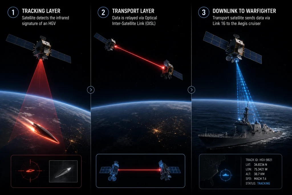
Tracking a Mach 10 vehicle from orbit and transmitting its exact coordinates to a terrestrial interceptor in milliseconds requires a flawlessly integrated hardware stack. Here is the first-principles breakdown of the architecture.
1. The Fundamental Problem: Dim, Maneuvering Targets
Traditional ICBMs leave the atmosphere and follow a predictable parabolic curve. Hypersonic Glide Vehicles (HGVs) are boosted into the upper atmosphere but then detach and glide, skipping across the stratosphere. They generate aerodynamic heat, but it is vastly dimmer than a rocket booster. A satellite in GEO (22,000 miles away) lacks the infrared sensitivity to separate this faint heat signature from the thermal clutter of the Earth’s background.
2. The Core Mechanism: The Tracking Layer
The SDA solves this by placing the sensors in Low Earth Orbit (LEO), roughly 750 to 1,200 km above the surface. Because the laws of optics dictate that resolution increases as distance decreases, these satellites can easily detect the faint heat of a gliding hypersonic vehicle. The Tracking Layer features hundreds of satellites equipped with specialized infrared cameras that blanket the globe, ensuring that 95% of the Earth has at least two satellites looking at it at any given moment.
3. Technical Depth: Tipping and Cueing (WFOV to MFOV)
The system uses two types of sensors. Wide Field of View (WFOV) sensors act as the initial alarm; they stare at massive swathes of the Earth to detect the initial launch flash. However, WFOV lacks the precision required to guide a weapon. Once a WFOV sensor sees the threat, the system automatically “tips and cues” a Medium Field of View (MFOV) sensor on a nearby satellite. The MFOV sensor zooms in, calculating the precise, fire-control quality coordinates of the maneuvering missile.
4. Technical Depth: Optical Inter-Satellite Links (OISLs)
Once the coordinates are calculated, the data must reach a shooter on the ground. Historically, the satellite would have to wait until it flew over a friendly ground station to download the data. This delay is fatal against a Mach 10 threat.
The PWSA uses Optical Inter-Satellite Links (OISLs). Each satellite is equipped with free-space laser communication terminals. The tracking satellite shoots a laser beam to a neighboring satellite in the Transport Layer, which shoots it to another, routing the data across the vacuum of space at the speed of light.
5. Real-World Consequences: Link 16 Downlink
The Transport Layer acts as an orbital internet backbone.Once the data reaches a Transport satellite hovering directly over a U.S. Navy cruiser or an Army Patriot battery, the satellite uses standard radio frequencies (specifically the tactical data network known as Link 16) to beam the exact coordinates directly into the weapons system of the ship. The ship launches an interceptor missile, executing the kill chain purely based on telemetry provided from space.
PWSA Deployment: Tranche 0, Tranche 1, and Tranche 2 Rollouts
The PWSA is currently being constructed and launched in distinct “Tranches,” constantly upgrading capabilities every two years.
Tranche 0 (The Warfighter Immersion Tranche): Launched between 2023 and 2024, Tranche 0 consisted of 28 initial satellites (a mix of Transport and Tracking). The purpose of this layer was proof-of-concept—demonstrating that low-latency laser crosslinks and direct-to-ground tactical downlinks could actually function in a real-world military exercise before scaling the production lines.
Tranche 1 (The Initial Warfighting Capability): Rolling out through 2024 and 2025, Tranche 1 heavily scales the network. It includes over 126 Transport Layer satellites acting as the secure routing mesh, and dozens of Tracking Layer satellites equipped with advanced infrared sensors capable of genuinely tracking advanced missile threats globally. This tranche operationalizes the Link 16 downlinks, connecting the orbital mesh directly to existing user equipment on the ground.
Tranche 2 (Global Persistence): Scheduled to begin launching in 2026, Tranche 2 represents the maturity of the architecture. The SDA awarded massive contracts (exceeding $1.5 billion) to prime contractors like Lockheed Martin and L3Harris to build these highly capable satellites. Tranche 2 guarantees permanent, global, unblinking coverage, ensuring that a missile launched from anywhere on Earth is immediately detected and tracked without interruption.
Economic & Strategic Impact
The core strategic disruption of the PWSA is the Commoditization of the Defense Space Supply Chain.
Historically, the Pentagon relied on exquisite, bespoke satellites built slowly over a decade by a single prime contractor. The SDA has destroyed this monopoly by mandating a “spiral development” model. They acquire satellites in rapid two-year tranches, and they deliberately spread the contracts across multiple vendors (Lockheed Martin, Northrop Grumman, York Space Systems, Sierra Space).
This forces prime contractors to build their satellites using standardized, interoperable protocols. An optical laser terminal built by one company must be able to securely connect with a laser terminal built by a competitor on a different satellite. By commoditizing the bus and the communication links, the SDA has drastically lowered the cost of orbital defense infrastructure, fostering a hyper-competitive, commercial-style aerospace manufacturing market.
Advantages
- Inescapable Line of Sight: Because there are hundreds of satellites, a maneuvering hypersonic missile can never dip below the radar horizon or use the curvature of the Earth to hide.
- Extreme Resilience: An adversary cannot disable the network with ASAT weapons. Shooting down a handful of $15 million satellites to punch a temporary hole in the net costs the enemy more than the satellites themselves, and the mesh network simply routes around the damage.
- Low Latency Kill Chain:By routing data through the vacuum of space via OISLs (which travel exactly at the speed of light) and downloading it directly to shooters via Link 16, the system bypasses slow terrestrial processing centers.
Limitations
- Optical Pointing Tolerances: OISL laser beams are incredibly narrow. To maintain a data connection, two satellites traveling at 7 kilometers per second must aim their lasers at each other with microradian precision. Thermal expansion from entering and exiting the Earth’s shadow can physically warp the satellite chassis, causing the laser lock to drop and requiring complex recalibration.
- The Kessler Syndrome Risk: Deploying hundreds (eventually thousands) of satellites into LEO exacerbates orbital congestion. If a kinetic conflict occurs and satellites are destroyed, the resulting cloud of shrapnel could trigger a cascading chain reaction of collisions, threatening the viability of all Low Earth Orbit infrastructure.
- Onboard Processing Limits: Sending raw 4K infrared video of the Earth back to the ground requires too much bandwidth. The satellites must use onboard edge computing to run AI algorithms, separating the tiny heat signature of a missile from the background noise of the Earth, before only sending the exact coordinate numbers through the laser mesh.
Common Misconceptions
Misconception: The PWSA uses lasers to shoot down the missiles.
Reality: The lasers (OISLs) are strictly for communication. They act as fiber-optic cables made of light. The actual destruction of the hypersonic missile is handled by physical interceptor missiles launched from Navy ships or Army ground batteries.
Misconception: The SDA is just replacing GPS.
Reality: The PWSA is entirely separate from the GPS constellation (which resides in Medium Earth Orbit). While the PWSA does have a “Navigation Layer” intended to provide backup timing and positioning data if GPS is jammed, its primary mission is high-bandwidth data routing and missile defense tracking.
Misconception: One company builds the whole system.
Reality: To prevent a single point of failure and keep costs low, the SDA intentionally fractures the contracts. The constellation is a patchwork of satellites built by multiple different, competing defense contractors who are legally forced to make their hardware interoperable.
What Most People Miss
The disruptive capability of the Custody Layer.
While everyone focuses on tracking the missile after it launches, the true tactical genius of the PWSA is the Custody Layer.
Hypersonic glide vehicles and advanced ICBMs are launched from massive Transporter Erector Launchers (TELs) mounted on heavy trucks. These trucks drive around constantly to avoid being targeted. The PWSA Custody Layer aims to maintain 24/7 visual tracking of the unlaunched trucks while they are driving on the ground. By maintaining continuous “custody” of the launch vehicle, the Pentagon can theoretically execute a preemptive strike, destroying the hypersonic missile before the enemy ever has a chance to launch it.
Comparison Table
| Feature | Legacy System (SBIRS / GEO) | PWSA Tracking & Transport (LEO) |
| Orbit Altitude | ~35,000 km (Geostationary) | ~750 to 1,200 km (Low Earth Orbit) |
| Number of Satellites | Under 10 | 300 to 500+ |
| Target Capability | Bright, predictable ICBMs | Dim, maneuvering Hypersonics |
| Data Routing | Satellite-to-Ground Station | Satellite-to-Satellite (Optical Mesh) |
| Architecture Resilience | Low (Single point of failure) | Extreme (Self-healing mesh) |
| Acquisition Speed | ~10 Years per generation | ~2 Years per Tranche |
Case Study
Situation: The emergence of advanced Hypersonic Glide Vehicles (HGVs) developed by near-peer adversaries created an immediate crisis for the U.S. Missile Defense Agency. HGVs are designed specifically to exploit the gaps in traditional radar coverage, flying low enough to avoid early warning radars and maneuvering wildly to defeat interceptor algorithms.
Challenge: Develop a sensor architecture capable of unblinking global coverage with the fidelity to generate fire-control quality tracking data on low-heat targets, and do so without waiting 15 years for the traditional defense acquisition bureaucracy to approve a new mega-satellite.
Solution (The SDA Tranche Model): The Pentagon established the Space Development Agency in 2019. The SDA completely bypassed the traditional procurement system. They designed the PWSA as a proliferated constellation of hundreds of small, cheap satellites, divided into a Tracking Layer (IR sensors) and a Transport Layer (Laser comms). They mandated a rapid “spiral development” timeline, launching new tranches every 24 months.
Outcome: The SDA awarded multi-billion-dollar contracts to multiple vendors, forcing interoperability standards across the board. By 2024, Tranche 0 successfully demonstrated the viability of the optical crosslinks and tactical data downlinks. The architecture proved that a low-cost, decentralized web of sensors could effectively close the “sensor-to-shooter” kill chain directly from space, permanently neutralizing the evasive advantages of hypersonic weapons.
Lessons Learned: The PWSA initiative validated that the future of military infrastructure mirrors commercial tech: iterative software updates, decentralized hardware, and mass proliferation. By abandoning the pursuit of the “perfect” satellite in favor of hundreds of “good enough” satellites, the DoD established a resilient, inescapable high ground.
Future Outlook
Next 12–24 Months
The era of Tranche 1 Deployment and Multi-Vendor Interoperability. Through 2025, the SDA will fully populate the Tranche 1 architecture, placing over 160 satellites into orbit. The primary focus will be proving that an optical laser terminal built by Lockheed Martin can seamlessly, autonomously establish a high-speed data lock with a laser terminal built by Northrop Grumman while both satellites are moving at orbital velocities. Solving this handshake protocol is the absolute prerequisite for a functioning, decentralized internet in space.
Next 3–5 Years
The scaling of Tranche 2 and JADC2 Integration. As Tranche 2 launches begin in 2026, the network will achieve permanent global persistence. The PWSA will formally become the orbital backbone of Joint All-Domain Command and Control (JADC2). This means an F-35 fighter jet, an Army Patriot battery, and a Navy Aegis cruiser will all share the exact same tactical picture, routed instantaneously through the PWSA’s transport layer. The lines between branch-specific networks will dissolve into a unified, all-domain kill web.
Next 10 Years
The Autonomous On-Orbit Battle Management Layer. By the mid-2030s, the volume of data generated by thousands of tracking and custody satellites will be too massive for human operators to process. The PWSA will rely heavily on its “Battle Management Layer”. Satellites equipped with advanced AI microchips will independently process the infrared data, identify the hypersonic threat, calculate the intercept trajectory, and route the firing command directly to the optimal ground shooter—entirely autonomously, drastically compressing the kill chain to mere seconds.
Most Likely Scenario
The Proliferated Warfighter Space Architecture represents the death of the singular, vulnerable flagship. It proves that the most resilient system is a decentralized swarm. As the constellation scales to 500+ nodes, adversaries will recognize that blinding the U.S. military via anti-satellite warfare is no longer mathematically possible. The PWSA secures the high ground for the 21st century, ensuring that no weapon on Earth—no matter how fast it flies or how wildly it maneuvers—can hide from the unblinking eye of the orbital mesh.
Key Takeaways
- Traditional defense satellites are parked 22,000 miles away. They are great for spotting massive rocket launches, but useless for tracking the faint, unpredictable flight paths of modern hypersonic missiles.
- The Space Development Agency (SDA) is solving this by launching hundreds of small satellites into Low Earth Orbit (LEO), just a few hundred miles above the Earth, forming the Proliferated Warfighter Space Architecture (PWSA).
- These satellites use advanced infrared cameras to spot the heat of a gliding missile. Because they are so close to the Earth, they can track the threat relentlessly.
- Instead of bouncing signals down to Earth, the satellites talk to each other using invisible laser beams (Optical Inter-Satellite Links), creating a lightning-fast internet in space.
- Once a satellite calculates exactly where the hypersonic missile is going, it beams the coordinates directly down to a Navy ship or Army missile battery, allowing them to shoot the threat down instantly.
- By using hundreds of cheap satellites instead of five expensive ones, the military ensures that even if an enemy shoots down several satellites, the network heals itself and the defense shield remains unbroken.
Glossary
Anti-Access/Area Denial (A2/AD): A military strategy that uses long-range missiles and radars to prevent an enemy from entering a specific geographic region. The PWSA is designed to defeat this by tracking the missiles from space.
Custody Layer: A planned layer of the PWSA designed to track objects on the ground, such as the trucks carrying the missiles, before they are even launched.
Hypersonic Glide Vehicle (HGV): A weapon that is boosted into the upper atmosphere and then detaches, gliding toward its target at Mach 5 or higher while maneuvering wildly to avoid interceptors.
Low Earth Orbit (LEO): The area of space close to the Earth’s surface (roughly 100 to 1,200 miles up). Satellites in LEO orbit very fast and provide much higher resolution imaging than distant satellites.
Optical Inter-Satellite Links (OISL): The technology that allows satellites to communicate directly with each other using highly precise, secure laser beams in the vacuum of space, entirely bypassing ground stations.
Transport Layer: The communication backbone of the PWSA. A massive mesh network of satellites that routes data globally and connects directly to tactical military systems on Earth (like Link 16).
Sources
Space Development Agency (SDA): Proliferated Warfighter Space Architecture (PWSA) Overview
Department of Defense (DoD): SDA Awards Contracts for Tranche 2 Tracking Layer
Wikipedia: Space Development Agency and National Defense Space Architecture
C4ISRNET: OISL and the Future of Space-Based Laser Communications
Air & Space Forces Magazine: The Shift from GEO to LEO Missile Tracking