Advertisement
)


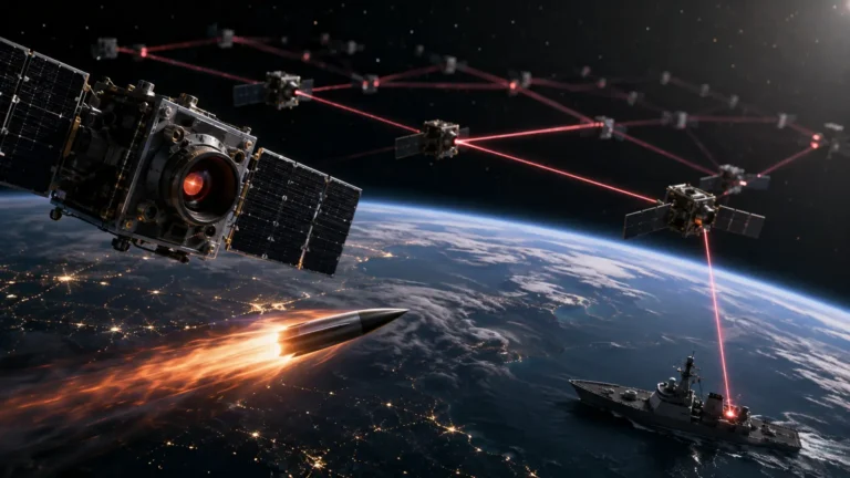
Imagine a mechanized armored division attempting a surprise border invasion at two o’clock in the morning under the cover of a massive, Category-4 hurricane. Traditional optical spy satellites passing overhead are completely useless; their cameras stare blindly into miles of thick black clouds. For decades, bad weather and nighttime were the ultimate cloaking devices for military maneuvers. But physics has a loophole. High-frequency microwaves do not care about clouds, rain, or the absence of sunlight. By firing active pulses of electromagnetic energy from orbit, a radar satellite can strip away the storm and capture a perfect, millimeter-precise image of the tanks moving in the dark below.
Why should you care right now? Because the geopolitical monopoly on this technology has collapsed. Historically, launching a radar satellite required the multi-billion-dollar budget of a superpower like the United States. Today, aerospace companies have shrunk these massive radars down to the size of a dishwasher. European nations are realizing that renting satellite photos from commercial companies is a massive strategic vulnerability during a war. Instead, countries like Poland are buying their own private fleets of Synthetic Aperture Radar (SAR) satellites, launching them in less than a year. This aggressive pivot to “Sovereign SAR” is democratizing the ultimate high ground, ensuring that even mid-sized militaries possess unblinking, all-weather x-ray vision from space.
What is a Sovereign SAR Constellation?
A Sovereign SAR Constellation is a dedicated fleet of Synthetic Aperture Radar satellites wholly owned, operated, and cryptographically controlled by a single nation’s military or intelligence agency. Unlike commercial imagery rentals, sovereign SAR guarantees immediate, undisputed tasking authority, ensuring continuous all-weather ground reconnaissance without relying on foreign intelligence sharing.
At a Glance
- Concept: A private fleet of radar satellites that bounce microwaves off the Earth, seeing through clouds and darkness to map the ground in perfect detail.
- Why it matters: Optical cameras are blind 60% of the time due to clouds and night. SAR operates 24/7/365, ensuring military targets can never hide under the weather.
- Who uses it: Mid-sized militaries (like Poland and Germany) partnering with agile aerospace manufacturers (like ICEYE) to build proprietary space forces.
- Biggest takeaway: Nations no longer want to “rent” pictures from commercial companies, because commercial companies can be blocked, hacked, or bought out. Sovereign ownership guarantees that a nation’s intelligence pipeline can never be legally or politically severed.
In Simple Words
Think of a standard spy satellite like a digital camera. It is passive. It sits in space and waits for sunlight to bounce off the Earth and into its lens. If it is night, or if there is a cloud in the way, the camera sees nothing.
A SAR satellite is not a camera; it is a flashlight. It actively brings its own energy.
It shines a massive “beam” of microwave radiation down to Earth. The microwaves pass right through the clouds, hit the ground, and bounce back up to the satellite. Because the satellite provided its own energy, it works flawlessly in pitch-black darkness. Because microwaves are long enough to ignore water vapor, the clouds are functionally invisible.
In the past, these “flashlights” cost $2 billion each. Now, they cost $10 million. Instead of paying a subscription fee to borrow America’s flashlight, smaller countries are buying a dozen of their own and keeping the on/off switch exclusively in their own military headquarters.
Why This Matters
For Defense Analysts, Space Investors, and Geopolitical Strategists, Sovereign SAR represents the Eradication of the Intelligence Umbrella.
Since the Cold War, European defense strategies relied heavily on the United States to act as the intelligence umbrella. The U.S. National Reconnaissance Office (NRO) controlled the orbital high ground. The Ukraine conflict exposed the fragility of this reliance. If U.S. priorities shift to the Pacific, European intelligence pipelines dry up. Sovereign SAR permanently closes this vulnerability. By owning the physical hardware and the cryptographic keys, allied nations guarantee unthrottled access to tactical targeting data. This shifts the geopolitical power dynamic—transforming European militaries from intelligence consumers into intelligence peers capable of independent, deep-strike targeting.
Sovereign Ownership vs. Commercial Satellite Rental
The space industry operates on a spectrum from “Commercial” to “Sovereign.”
Commercial operators (like Maxar or Planet) sell imagery to anyone with a credit card. However, during a crisis, their tasking queues get congested, and host-nation laws can arbitrarily forbid them from taking pictures of certain conflict zones.
“Sovereignty” means absolute control. A sovereign constellation means the servers are physically located inside the country’s borders, operated by uniformed military personnel, heavily encrypted, and entirely immune to foreign export controls (ITAR-free). It is the ultimate expression of national autonomy in the 21st century.
How Synthetic Aperture Radar (SAR) Satellites Work
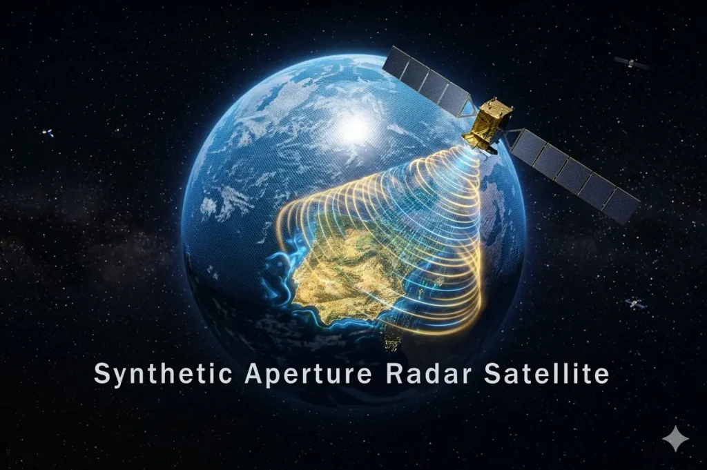
Capturing a high-resolution image of a tank from 500 kilometers away using invisible radio waves requires manipulating the physics of orbital mechanics. Here is the first-principles breakdown of the architecture.
1. The Fundamental Problem: Antenna Physics
A radar’s resolution is strictly dictated by the physical length of its antenna. A long antenna creates a sharp image; a short antenna creates a blurry image. To get a crisp 25-centimeter resolution image of the ground using an X-band radar from Low Earth Orbit, you would mathematically need an antenna over two miles long. Launching a two-mile-long piece of metal into space is physically impossible.
2. The Core Mechanism: The “Synthetic” Aperture
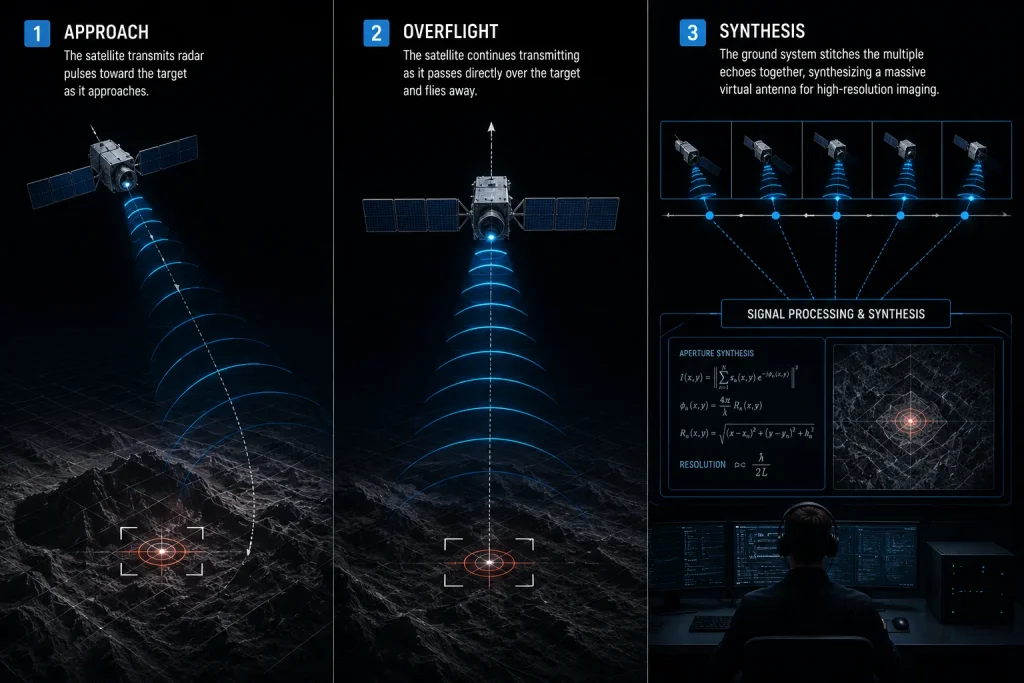
Engineers bypass this physical limit using time and speed. A SAR satellite travels at roughly 17,000 miles per hour. As it approaches a target on the ground, it fires thousands of rapid radar pulses. It records the echoes as it approaches, as it passes directly overhead, and as it flies away.
3. Technical Depth: Signal Processing
A massive supercomputer takes all of these individual radar echoes and stitches them together. Because the satellite moved several miles during the time it took to record all the echoes, the computer mathematically pretends that the thousands of small echoes came from one massive, miles-long antenna. The aperture (the antenna) is literally “synthesized” via software, creating breathtaking resolution from a device the size of a mini-fridge.
4. Technical Depth: X-Band Penetration
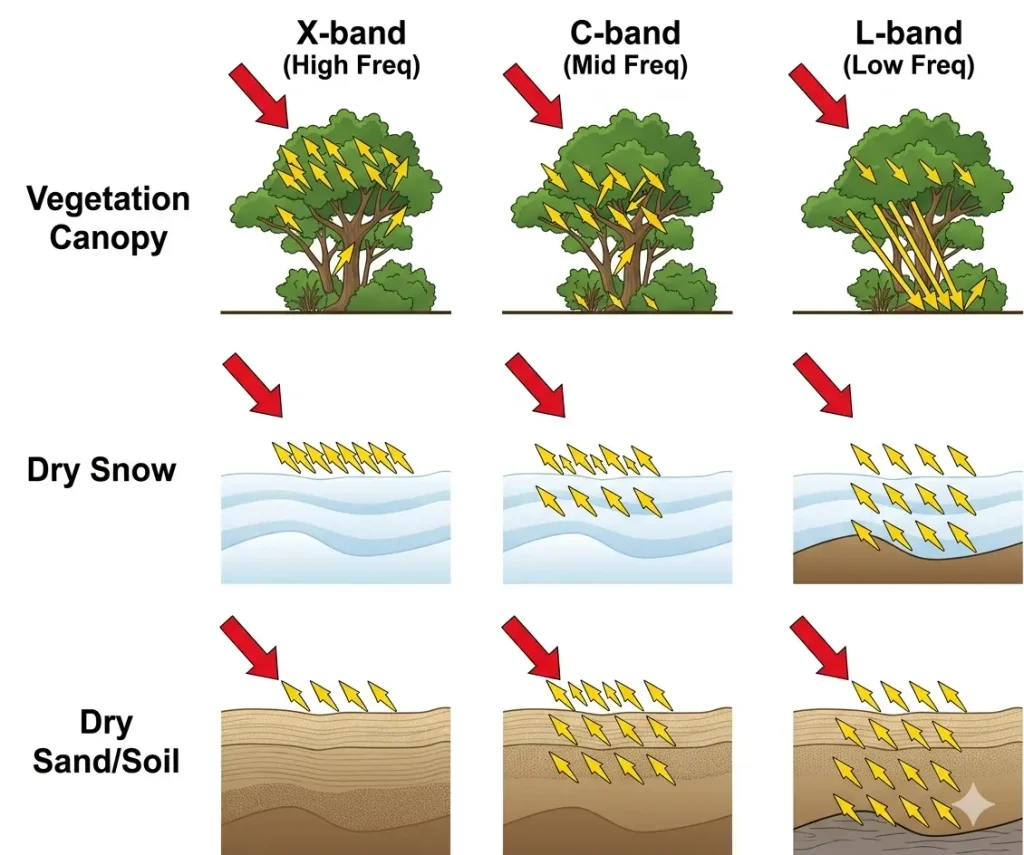
Not all radar is the same. The wavelength dictates what you see.
- L-Band (24 cm): Long waves. They blast through leaves and tree canopies to hit the solid ground underneath (used to find hidden bunkers in forests).
- X-Band (3 cm): Short waves. They reflect strongly off hard, angular metal surfaces. X-band is the undisputed king of military SAR because a metal tank, a jet fighter, or a concrete bunker bounces X-band microwaves back like a mirror, lighting up the radar image with distinct, sharp geometries.
5. Real-World Consequences: Active Phased Arrays
Modern SAR satellites do not use moving satellite dishes. They use Active Electronically Scanned Arrays (AESA). The flat radar panel has hundreds of tiny transmitters. By tweaking the timing of when each transmitter fires by a fraction of a nanosecond, the satellite can physically “steer” the radar beam backward or forward without the satellite physically moving. This allows the satellite to “stare” at a single target for a longer time as it flies past, sucking up massive amounts of data to produce hyper-detailed imagery.
Orbital Reconnaissance: Optical vs. SAR
Adjust the sensor type and environmental conditions to observe intelligence gathering capabilities.
Clear Noon
Midnight
Heavy Storm
Sovereign SAR Deployments: The Polish POLSARIS Network
The transition from theoretical requirement to physical deployment is moving at an unprecedented velocity, completely bypassing traditional military procurement sluggishness.
The Polish POLSARIS Constellation: Poland’s proximity to a kinetic warzone dictated an urgent need for autonomous intelligence. In May 2025, they signed a €200 million contract with ICEYE (a leader in miniaturized SAR) for the MikroSAR program.In a staggering display of agile aerospace manufacturing, ICEYE built, launched, and handed over the fully operational 4-satellite POLSARIS constellation by May 2026—less than 12 months after contract signature. The Polish military agency ARGUS now holds absolute, independent control over the tasking and telemetry.
Border Security and Maritime Smuggling: SAR is highly sensitive to the way water ripples. When a ship moves through the ocean, it creates a distinct “wake” pattern. Even if an illegal smuggling vessel or a military submarine turns off its AIS tracking beacon to go “dark,” a SAR satellite will instantly illuminate the metallic hull of the ship and its physical wake against the dark background of the ocean. Sovereign SAR allows coast guards to map their entire Exclusive Economic Zones (EEZ) multiple times a day.
Battle Damage Assessment (BDA): After a military strikes a target with cruise missiles, they must confirm if the target was actually destroyed before launching a second volley. If the target is covered in thick smoke from the explosion, optical satellites cannot see the crater. Sovereign SAR penetrates the smoke plume instantly, providing command centers with real-time structural assessments of the blast radius, optimizing munitions stockpiles.
Economic & Strategic Impact
The core strategic disruption is the Commoditization of the Space Bus.
Historically, European nations like France spent billions developing bespoke, heavy-class reconnaissance satellites (like the CSO optical series), requiring nearly a decade of lead time.
The ICEYE model has turned SAR satellites into an assembly-line commodity. The “bus” (the chassis, power, and propulsion) is standardized. When a country wants a sovereign fleet, the manufacturer simply pulls four identical satellites off the production line, customizes the encryption software to the host nation’s military standards, and places them on a SpaceX rocket. This drops the capital expenditure (CapEx) from billions to roughly €200 million, shifting orbital intelligence from a luxury good into a mandatory baseline capability for modern militaries.
Advantages
- All-Weather, 24/7 Operations:Emits its own energy and operates on wavelengths that pass through water vapor, entirely ignoring clouds, fog, smoke, and darkness.
- Guaranteed Tasking Authority: Sovereign ownership ensures that a nation’s intelligence requests are prioritized 100% of the time, without waiting in a commercial queue or facing geopolitical censorship.
- Rapid Revisit Rates: Owning a constellation of multiple small satellites (rather than one massive one) means a specific target on Earth can be imaged every few hours, rather than waiting days for a single satellite to return.
- ITAR-Free Supply Chain:By utilizing European aerospace firms like ICEYE, nations bypass the restrictive and slow U.S. International Traffic in Arms Regulations (ITAR), ensuring absolute autonomy over the hardware and data sharing.
Limitations
- Speckle Noise: SAR images do not look like normal photographs. They look like grainy, black-and-white x-rays covered in a “salt-and-pepper” static called speckle. Interpreting a SAR image requires highly trained analysts or specialized AI machine vision models.
- Swath vs. Resolution Tradeoff: You cannot have both a wide picture and a sharp picture simultaneously. If the military wants a 25-centimeter hyper-resolution image to identify a specific truck, the “swath” (the width of the picture) shrinks to a tiny patch of land. Finding the truck in the first place requires wide-swath scanning at lower resolutions.
- Power Consumption: Active radar requires massive amounts of electrical power. While miniaturized satellites can generate the power needed for a quick burst of imaging, their small solar panels and batteries require them to “rest” and recharge frequently, limiting continuous, unbroken surveillance over long stretches of the globe.
Common Misconceptions
Misconception: Sovereign SAR is just buying a subscription to a commercial provider.
Reality: A sovereign contract means the buyer physically owns the hardware in space. The data downlinks go directly to secure military ground stations within the buyer’s country, bypassing the commercial operator entirely.
Misconception: Radar satellites can see through roofs to track people inside buildings.
Reality: X-band SAR bounces off solid metal and concrete roofs. It cannot see inside a building or track humans walking inside a facility.
Misconception: You only need SAR, and optical satellites are obsolete.
Reality: SAR lacks color, texture, and contextual nuance. A perfect intelligence pipeline uses SAR to pierce the clouds and find the target’s geometry, and Optical to verify the target’s identity once the clouds clear. They are highly complementary.
What Most People Miss
The disruptive intelligence value of Interferometric SAR (InSAR).
Taking one picture of a tank is useful. But the true superpower of SAR is taking two pictures of the same piece of land on different days and mathematically comparing the phase of the radar waves. This is called Interferometric SAR (InSAR).
InSAR can detect physical changes in the ground elevation down to the millimeter. If an adversary builds an underground nuclear centrifuge or a hidden tunnel, the ground above it will shift by a few millimeters as the earth settles. To the naked eye, the dirt looks untouched. To a sovereign SAR constellation utilizing InSAR, the microscopic subsidence of the dirt glows like a neon sign, completely unmasking deep-underground military infrastructure.
Comparison Table
| Feature | Sovereign Optical Constellation | Commercial SAR Rental | Sovereign SAR Constellation |
| All-Weather Capability | Zero (Blinded by clouds/night) | High | High |
| Tasking Priority | Absolute | Subject to queue/commercial bans | Absolute |
| Data Security | High | Moderate (Stored on third-party servers) | Absolute (Encrypted direct-to-military) |
| Deployment Speed | Slow (Historically bespoke) | Instant (If renting access) | Ultra-Fast (<12 months via COTS scaling) |
| Cost | Very High | Low (OpEx Subscription) | Moderate (CapEx ~€200M) |
Case Study
Situation: Following the escalation of hostilities in Eastern Europe, the Polish Armed Forces realized an acute vulnerability: they lacked independent, all-weather orbital reconnaissance. Relying on NATO allies or commercial vendors introduced unacceptable latency into their kill chain. They needed the ability to independently target hostile armor and track troop movements through the heavy cloud cover that plagues the region during winter.
Challenge: Procuring a military-grade satellite network historically required a 5 to 10-year development cycle and a massive domestic aerospace engineering base, neither of which aligned with Poland’s immediate tactical timeline.
Solution (The MikroSAR Procurement): In May 2025, Poland completely bypassed traditional defense procurement. They contracted ICEYE, a commercial leader in miniaturized SAR, to provide a turnkey “Sovereign SAR” package known as MikroSAR.ICEYE utilized its existing, high-rate production lines to build four identical, customized SAR satellites.
Outcome: By May 2026—a record-breaking 12 months after contract signature—the entire four-satellite POLSARIS constellation was in orbit.Furthermore, ICEYE integrated the ground segment and trained Polish military personnel to operate the satellites independently.ARGUS, Poland’s new Geospatial Reconnaissance Agency, assumed absolute, sovereign control over the constellation.
Lessons Learned: The deployment shattered the legacy paradigm of space procurement. It proved that off-the-shelf, standardized commercial space architectures can be rapidly adapted into highly secure, sovereign military assets. Poland demonstrated that information autonomy can be bought and deployed in a single fiscal year, establishing a new blueprint for European defense capability.
Future Outlook
Next 12–24 Months
The era of Rapid Sovereign Proliferation. Poland’s 12-month deployment will trigger a cascade of similar procurement contracts across Europe and the Middle East. Mid-sized economic powers (like Greece, Portugal, and the UAE) will aggressively launch their own sovereign SAR nodes to secure their regional intelligence autonomy. ICEYE and competing manufacturers will pivot from selling data subscriptions to operating as turnkey “Constellation-as-a-Service” hardware providers, effectively establishing franchise space forces for allied nations.
Next 3–5 Years
The scaling of On-Orbit Edge AI Processing. Currently, SAR satellites beam massive, raw data files down to Earth, where massive ground servers spend hours processing the echoes into a readable picture. Over the next five years, satellites will be equipped with specialized Neural Processing Units (NPUs). The satellite will use AI to process the raw radar data in orbit, instantly identifying enemy tanks or ships within milliseconds. Instead of sending down a 5-gigabyte image file, it will send a 2-kilobyte text message containing the exact GPS coordinates of the target directly to a tactical commander’s tablet.
Next 10 Years
The Federated NATO Orbital Mesh. By the mid-2030s, the skies will be filled with dozens of independent, sovereign SAR constellations owned by individual European nations. To maximize efficiency, these nations will utilize encrypted, blockchain-like smart contracts to seamlessly cross-task and share capabilities. If Poland’s satellite is out of position, it will automatically “borrow” a pass from Germany’s sovereign satellite in real-time. This federated approach will create an unblinking, continent-wide radar mesh that operates as a single, indestructible entity without requiring a centralized owner.
Most Likely Scenario
Sovereign SAR constellations represent the death of the intelligence monopoly. The ultimate high ground is no longer restricted to superpowers. By combining the physics of active radar with the mass-manufacturing economics of commercial space, sovereign SAR guarantees that any nation willing to spend a fraction of its defense budget can secure permanent, inescapable visibility over its borders, fundamentally altering the calculus of stealth and surprise in modern warfare.
Key Takeaways
- Standard optical spy satellites are useless at night and cannot see through clouds. Synthetic Aperture Radar (SAR) emits microwave energy that blasts through bad weather to generate perfect images 24/7.
- To get high resolution, a radar needs a massive antenna. SAR “synthesizes” an antenna using software, taking thousands of pictures as the satellite flies at 17,000 mph and stitching them together.
- European militaries are shifting from renting commercial imagery to buying their own “Sovereign” constellations, ensuring they have absolute, cryptographically secure control over their intelligence.
- Aerospace companies like ICEYE have shrunk these satellites to the size of a dishwasher and standardized production, dropping costs from billions to millions.
- In a historic achievement, Poland purchased and launched a fully operational, 4-satellite sovereign SAR constellation (POLSARIS) in under 12 months.
- SAR can also detect changes in the ground down to the millimeter (InSAR), easily unmasking hidden underground bunkers or secret tunnels by measuring the microscopic shifting of the dirt above them.
Glossary
Active Electronically Scanned Array (AESA): A flat radar panel that steers its radar beam electronically in milliseconds without physically moving the satellite, allowing it to lock onto a target for higher resolution.
Interferometric SAR (InSAR): A technique that compares two radar images taken on different days to measure microscopic changes in ground elevation, useful for detecting underground construction or earthquakes.
Sovereign Constellation: A satellite network that is wholly owned, operated, and encrypted by a specific nation’s military, ensuring no foreign entity or commercial company can block or view the data.
Synthetic Aperture Radar (SAR): An active sensor that emits microwave pulses to illuminate the ground, completely ignoring clouds and darkness to generate high-contrast, black-and-white imagery.
Tasking Authority: The absolute power to command a satellite to look at a specific target at a specific time. In commercial networks, users wait in line; in sovereign networks, the military has instant priority.
X-Band Radar: A specific, short-wavelength (approx. 3 cm) microwave frequency used in SAR. It is highly sensitive to hard, metallic edges, making it the perfect tool for identifying military vehicles and ships.
Sources
ICEYE: ICEYE delivers MikroSAR system to Polish Armed Forces in under 12 months
SatNews: How ICEYE Turned Sovereign SAR Into a 12-Month Product
ICEYE Press Release: ICEYE to provide SAR satellites for the Armed Forces of Poland
NASA Earthdata: Synthetic Aperture Radar (SAR) Basics
Detektia: Learn about Synthetic-Aperture Radar (SAR) and X-Band characteristics