Advertisement
)

Low Earth Orbit (LEO) satellites move at 17,000 miles per hour. If a military commander needs to monitor a specific target—a hostile border crossing or a rogue naval fleet—a satellite will fly over it in mere minutes, leaving a massive intelligence blind spot until its next orbit. Traditional drones can circle the target, but they burn heavy jet fuel and must return to base within a day, physically breaking the chain of surveillance. This creates an unfillable gap in modern intelligence gathering: the inability to establish a permanent, unblinking eye in the sky.
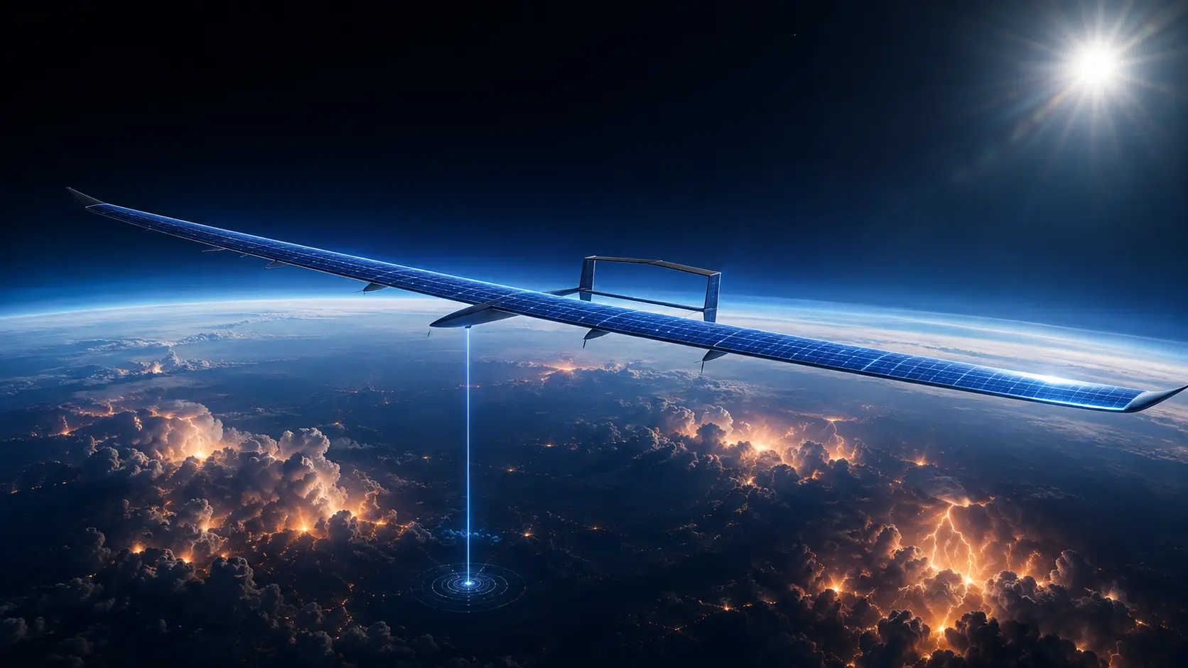
Why should you care right now? Because aerospace engineers are aggressively colonizing the stratosphere. By building massive, ultra-lightweight carbon-fiber gliders covered entirely in solar panels, defense and telecom companies have created High-Altitude Pseudo-Satellites (HAPS). These autonomous aircraft fly at 65,000 feet—twice the height of commercial airliners—where the weather is perfectly calm and the sun is blindingly clear. They can park over a single city or ocean strait for months at a time without ever landing, effectively replacing multi-million-dollar space hardware with a reusable, highly modular fleet of stratospheric spies.
What are High-Altitude Pseudo-Satellites (HAPS)?
High-Altitude Pseudo-Satellites (HAPS) are uncrewed, solar-powered aircraft or airships designed to operate continuously in the stratosphere for months. By flying above standard weather and commercial air traffic, they function as stationary, low-cost alternatives to satellites, delivering persistent earth observation, intelligence gathering, and broad-area telecommunications coverage.
At a Glance
- Concept: Building a drone with wings longer than a Boeing 737, covering it in solar panels, and leaving it to float at the edge of space for half a year.
- Why it matters: Launching a satellite into space requires a massive, explosive rocket. If the satellite’s camera breaks, you cannot fix it. A HAPS takes off from a regular runway, can be brought down for software upgrades, and costs a fraction of the price.
- Who uses it: The US Department of Defense, border security agencies, and major telecommunications firms pushing 5G access into remote regions without cell towers.
- Biggest takeaway: HAPS live and die by the sun. The engineering is an extreme balancing act: the plane must harvest enough solar energy during the day to survive flying through the cold darkness of the night.
In Simple Words
Imagine you want to monitor a stadium to see exactly who goes in and out, 24/7.
If you use a satellite, it is like driving past the stadium at 100 mph, taking a single picture out the window, and driving away. You only get snapshots.
If you use a standard military drone, it is like hovering a helicopter over the stadium. You can watch a continuous video, but after a few hours, you run out of gas and have to land.
A HAPS is like building a 60-foot observation tower directly above the stadium and sitting on it indefinitely. Because it runs purely on sunlight, it never needs to refuel. It just sits there, perfectly stationary, watching the doors without ever blinking, week after week.
Why This Matters
For Aerospace Engineers, Telecom Executives, and Defense Analysts, HAPS solve the Revisit Rate vs. Resolution Paradox.
If a spy satellite is high enough to see an entire continent at once (Geostationary Orbit), it is too far away to take a high-resolution picture. If it is low enough to read a license plate (Low Earth Orbit), it is moving so fast that its “revisit rate”—the time it takes to circle the Earth and see that spot again—is usually several hours.
HAPS physically break this paradox. Operating at 65,000 feet, they are 30 times closer to the ground than a LEO satellite. This proximity means a cheap, lightweight camera on a HAPS can take significantly clearer, higher-resolution photos than a billion-dollar lens in space. More importantly, the revisit rate is instantaneous. Because the HAPS is loitering in a fixed circle directly above the target, it provides continuous, real-time, full-motion video of an area the size of a small country.
Micro-Insight: Proximity is power in optics. Being parked in the stratosphere means HAPS can provide sharper intelligence using cheap commercial sensors than space satellites using highly classified military sensors.
Operating in the Stratosphere
The Earth’s atmosphere is fiercely hostile to continuous flight.
The lowest layer, the Troposphere, is where humans live. It is violent, filled with thunderstorms, icing conditions, and thick clouds that block the sun.
Above the troposphere is the Stratosphere. This is the golden zone. At 65,000 feet, the air is incredibly thin, there are virtually no clouds, and the sun shines unimpeded during the day. It is perfectly calm. HAPS are specifically designed to punch through the violent weather below and safely park themselves in this serene, frozen layer, transforming the stratosphere from empty sky into highly valuable, contested real estate.
Altitude Persistence Comparison
Intelligence Platform Simulator
Altitude, Coverage, and Persistence: LEO vs. MALE vs. HAPS
Operating Altitude
65,000 ft
Target Persistence
Months
Status / Overwatch
PERMANENT UNBLINKING COVERAGE
Strategic Impact: LEO Satellites orbit too fast, creating massive blind spots (revisit rates). MALE Drones provide excellent resolution but are hindered by turbulent weather and aviation fuel limits (Bingo Fuel). HAPS park safely in the calm Stratosphere, using solar power to provide the permanent, uninterrupted surveillance of a satellite with the high-resolution proximity of an atmospheric drone.
How High-Altitude Pseudo-Satellites (HAPS) Work
Keeping an aircraft aloft for months without landing requires absolute thermodynamic perfection. Here is the first-principles breakdown of the architecture.
1. The Fundamental Problem: The Weight of Fuel
A traditional aircraft uses 40% of its total weight just to carry the fuel needed for the flight. If you want a drone to fly for three months, it is mathematically impossible to carry enough jet fuel to keep the engines running. You must abandon combustion entirely.
2. The Core Mechanism: Extreme Aspect Ratios
To fly using almost zero power, the aircraft must be an extraordinary glider. HAPS (like the Airbus Zephyr) are built entirely of ultra-thin carbon fiber. They feature an extreme “aspect ratio”—their wings are incredibly long and narrow (often spanning over 80 feet), yet the entire aircraft weighs less than a human being (under 160 lbs). This allows the HAPS to generate massive lift in the thin stratospheric air while barely spinning its electric propellers.
3. Technical Depth: The Diurnal Cycle
The entire mission depends on surviving the night.
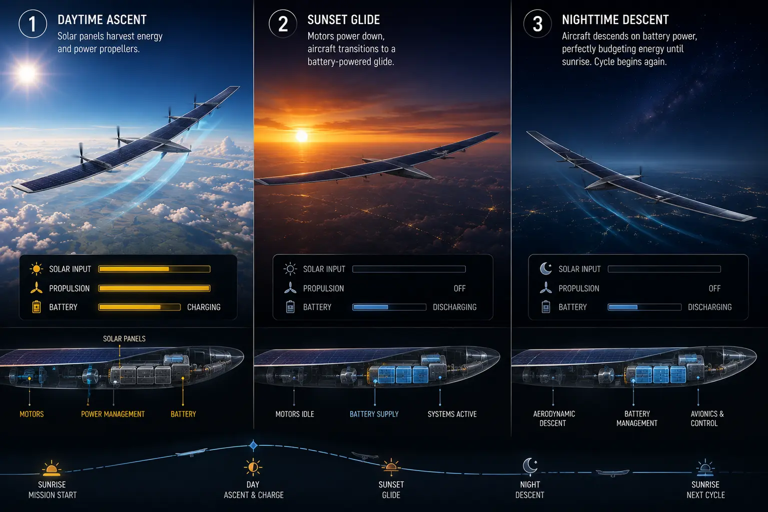
During the day, paper-thin solar panels covering the massive wings capture solar radiation. This energy powers the electric motors to keep the plane flying, while simultaneously dumping excess energy into a bank of high-density lithium-sulfur or lithium-ion batteries.
When the sun sets, the aircraft begins its “diurnal cycle.” It cuts power to the motors and enters a slow, controlled glide. As it slowly sinks through the stratosphere overnight, it carefully bleeds battery power to keep the sensors running. It must perfectly budget its altitude and battery so that it reaches sunrise before hitting the turbulent troposphere.
Takeaway: A HAPS doesn’t just fly forward; it “breathes” vertically. It climbs high during the day to store potential energy, and slowly sinks at night to save battery power.
HAPS Solar Energy Simulator
HAPS Diurnal Energy Simulator
24-Hour Solar Charging & Battery Discharge Cycle
0° (Equator)
Equator
Polar Region
AVAILABLE DAYLIGHT:
12.0 Hours
SOLAR INTENSITY:
100%
SYSTEM NOMINAL: INFINITE PERSISTENCE MAINTAINED
Physics Principle: The Diurnal Cycle is the ultimate survival test for a HAPS. During the day, the aircraft harvests solar energy to charge its batteries and climb high into the stratosphere (storing potential energy). At night, it shuts down its motors and executes a highly controlled, hours-long glide, bleeding battery power solely for avionic sensors. If operating in high latitudes during winter, the abbreviated daylight prevents the batteries from reaching 100%, causing the aircraft to deplete its reserves and stall before sunrise.
4. Technical Depth: Synthetic Aperture Radar (SAR)
Standard cameras are useless if there is a cloud layer directly beneath the HAPS blocking its view of the ground. To provide true, 24/7 overwatch, HAPS carry miniaturized Synthetic Aperture Radar (SAR). SAR shoots microwave pulses through the clouds and rain, bouncing off the earth to create a 3D topographic map. Historically, SAR required massive power generated by jet engines. Modern GaN (Gallium Nitride) amplifiers have shrunk SAR radar to fit within the strict 100-watt power budget of a solar glider.
5. Real-World Consequences: 5G Telecommunications
HAPS are not just spy planes; they are flying cell towers. Laying fiber-optic cables or building cell towers in the Amazon rainforest or the Sahara Desert is economically unviable. A single HAPS parked at 65,000 feet provides a direct line-of-sight footprint of roughly 4,500 square miles. By equipping a HAPS with 5G transceivers, telecom companies can beam high-speed internet directly down to standard, unmodified smartphones across massive rural expanses.
Commercial and Military Applications for HAPS
The deployment of HAPS is actively reshaping global security and communications infrastructure.
Maritime Domain Awareness (MDA): Tracking illegal fishing, piracy, or hostile submarine activity across the vastness of the Pacific Ocean is incredibly difficult. Drones lack the range, and ships are too slow. A defense agency can launch a HAPS from a runway in California, fly it out over the deep Pacific, and park it above a critical shipping lane. It provides continuous radar tracking of every vessel in a 200-mile radius for months, beaming the data directly to naval headquarters.
Disaster Response and C4ISR: When a Category 5 hurricane destroys an island nation (like Puerto Rico), the local cell towers and power grid are instantly wiped out. First responders are left blind. A HAPS can be rapidly flown over the disaster zone from a safe base 1,000 miles away. It instantly restores emergency 5G communications and provides real-time flood mapping via SAR radar to guide rescue helicopters.
Direct-to-Device (D2D) Connectivity: Major telecom consortiums (like SoftBank’s HAPSMobile) are actively testing HAPS to bridge the global digital divide. Unlike Starlink (LEO satellites), which requires a specialized dish on your roof to catch the signal, a HAPS is close enough to the ground that it can communicate directly with the standard LTE/5G antenna inside an iPhone.
Micro-Insight: Satellites require you to buy new ground hardware. HAPS act exactly like normal cell towers, just mounted on an incredibly tall, invisible pole.
Economic & Strategic Impact
The core strategic consequence of HAPS is the Democratization of Strategic Intelligence.
Historically, possessing permanent, high-resolution surveillance over a foreign nation required a sovereign space program. A nation had to spend billions developing launch vehicles, orbital mechanics, and hardened satellite buses.
HAPS completely bypass the space domain. They take off from a standard asphalt runway using a few electric propellers. Any nation with a defense budget of a few million dollars can purchase a HAPS platform, load it with commercial-off-the-shelf (COTS) optical sensors, and establish permanent strategic overwatch of their borders. By moving the ultimate high ground from orbit down to the stratosphere, HAPS mathematically level the intelligence playing field between superpowers and developing nations.
Advantages
- Fractional Cost: Manufacturing a HAPS and taking off from a runway costs tens of millions of dollars less than securing a payload spot on an orbital rocket.
- Zero Latency Loitering: Provides absolute 24/7 continuous coverage of a specific target, entirely eliminating the “revisit rate” blind spots of satellites.
- Upgradability: Space satellites cannot be repaired or upgraded. A HAPS can be flown back down to the runway, fitted with a next-generation radar or updated software, and relaunched the next morning.
- No Space Debris Risk: HAPS operate entirely in the atmosphere. They are completely insulated from the rising threat of orbital collisions (Kessler Syndrome) or anti-satellite (ASAT) kinetic strikes.
Limitations
- The Winter Latitude Trap: Solar gliders require intense, prolonged sunlight. During the winter, high-latitude regions (like Northern Europe or Canada) experience very short days and long nights. A HAPS mathematically cannot capture enough solar energy during a 6-hour winter day to keep its batteries alive through an 18-hour night.
- Stratospheric Wind Shear: While the stratosphere is mostly calm, anomalies occur. If a HAPS encounters a stratospheric jet stream blowing at 80 mph, its weak electric motors cannot fight the headwind. It will be physically blown off its station.
- Microscopic Payload Budgets: A HAPS is an exercise in extreme anorexia. A massive 80-foot glider can typically only carry a 10 kg to 50 kg payload. Every single gram of sensor equipment competes directly with the weight of the batteries needed to keep the plane alive.
Common Misconceptions
Misconception: HAPS are just big weather balloons.
Reality: There are stratospheric balloons (like Project Loon), but a true HAPS is a fixed-wing glider. Balloons are at the mercy of the wind and drift unpredictably. A fixed-wing HAPS has propellers and active flight controls, allowing it to deliberately fight the wind and hold a specific GPS coordinate (station-keeping).
Misconception: They can fly forever without landing.
Reality: The limiting factor is usually the battery chemistry or mechanical wear. Lithium-ion batteries degrade after hundreds of deep charge/discharge cycles. The lubricant in the electric motors eventually freezes or wears out in the -70°C cold. The current physical limit for continuous flight is several months, not years.
Misconception: They are invisible to enemy radar.
Reality: While they are physically thin, their massive, 80-foot solar wings reflect radar effectively. Because they fly incredibly slowly (often just 30 mph), they are easy targets for high-altitude surface-to-air missiles (SAMs) if flown directly into contested, hostile airspace.
What Most People Miss
The disruptive capability of Regenerative Fuel Cells (RFCs).
When analysts look at the limitations of HAPS, they focus on the weight of lithium-ion batteries. Batteries are incredibly heavy, dragging down the aircraft’s performance. What they miss is the imminent transition to Regenerative Fuel Cells.
Instead of heavy batteries, an RFC uses a closed loop of water. During the day, excess solar power splits the water into Hydrogen and Oxygen (electrolysis). At night, the fuel cell recombines the Hydrogen and Oxygen, creating electricity to run the propellers, and the byproduct is just water again. This closed-loop system is drastically lighter and holds significantly more energy per kilogram than lithium-ion. Once RFCs are miniaturized, HAPS will have enough energy density to effortlessly survive the long, dark nights of the northern winter, unlocking true year-round global persistence.
Comparison Table
| Feature | LEO Satellite | MALE Drone (e.g., Reaper) | HAPS (Stratospheric Glider) |
| Altitude | > 500 km (Space) | ~25,000 ft (Troposphere) | ~65,000 ft (Stratosphere) |
| Persistence (Loiter Time) | Minutes per orbit | 24 – 48 Hours | Months (Continuous) |
| Power Source | Solar / Battery | Aviation Jet Fuel | Solar / Battery (Diurnal) |
| Payload Capacity | Massive (Tons) | Large (Weapons/Heavy Radar) | Microscopic (< 50 kg) |
| Revisit Rate | Hours to Days | Instantaneous | Instantaneous |
Case Study
Situation: The UK Ministry of Defence required a persistent intelligence gathering mechanism that did not rely on the heavily congested and astronomically expensive procurement cycle of defense satellites. During counter-narcotics and maritime security operations, traditional drones were burning through their flight hours simply transiting from the runway to the target zone, leaving minimal time to actually watch the target before Bingo Fuel forced a return.
Challenge: Deploy an asset capable of remaining completely stationary above a theater of operations for weeks at a time, providing unbroken optical and radar telemetry, without relying on vulnerable supply chains of specialized aviation fuel.
Solution (The Airbus Zephyr Deployment): The MoD partnered with Airbus to aggressively field-test the Zephyr S, an ultra-lightweight HAPS boasting an 82-foot wingspan but weighing only 165 pounds. The Zephyr was launched by hand from a runway and immediately climbed into the stratosphere at 70,000 feet.
Outcome: During a record-breaking test flight in the summer of 2022, the Zephyr S remained entirely airborne for exactly 64 days, 18 hours, and 26 minutes. It survived over 60 brutal diurnal cycles, flawlessly charging its lithium-sulfur batteries during the day and gliding through the frozen night. It provided continuous, simulated 5G relay connectivity and optical surveillance down to the ground station.
Lessons Learned: The flight validated that the stratospheric domain is fully exploitable using current-generation photovoltaics. It proved that a solar glider can execute the exact same ISR (Intelligence, Surveillance, and Reconnaissance) mission as a LEO satellite for two straight months, effectively rewriting the military’s strategic playbook for low-cost, high-persistence overwatch.
Future Outlook
Next 12–24 Months
The era of Commercial 5G Stratospheric Nodes. In the immediate term, massive telecom conglomerates will launch commercial HAPS flights to act as backup cellular towers. During massive sporting events or music festivals where ground-based cell towers are overwhelmed, telecom providers will park a HAPS at 65,000 feet directly above the stadium to provide instant, high-bandwidth 5G relief. Expect the Federal Aviation Administration (FDA) and global regulators to finalize the strict air-traffic control protocols required for HAPS to safely ascend through commercial airspace to reach the stratosphere.
Next 3–5 Years
The scaling of Swarm Handoffs and Continental Mesh Networks. A single HAPS covers 4,500 square miles. Within five years, operators will deploy them in automated swarms. If HAPS ‘A’ needs to return to base for a software upgrade or maintenance, HAPS ‘B’ will fly to its exact coordinates. The two aircraft will execute a seamless, laser-linked data handoff, ensuring the ground users never lose their 5G connection. By linking dozens of these gliders together via optical laser communications, telecom giants will weave an invisible, floating internet mesh across entire continents.
Next 10 Years
The Hydrogen-Powered Year-Round Stratosphere. By the mid-2030s, the lithium-ion battery bottleneck will be broken. HAPS will integrate advanced regenerative hydrogen fuel cells, massively increasing their energy density. This technological leap will completely eliminate the “winter latitude trap.” HAPS will routinely park over London, New York, or the Arctic Circle in the dead of winter, easily surviving 18-hour nights. The stratosphere will become a highly congested, heavily regulated traffic layer, acting as the permanent, unblinking surveillance and communication canopy for the modern global economy.
Most Likely Scenario
High-Altitude Pseudo-Satellites represent the most profound disruption to orbital mechanics since the satellite itself. Space is expensive, unforgiving, and inflexible. The stratosphere is accessible, calm, and infinitely reusable. As battery densities cross the critical threshold required to survive the long winter nights, HAPS will rapidly transition from fragile experimental gliders into the undisputed, low-cost backbone of global telecommunications and sovereign intelligence.
Key Takeaways
- Satellites move too fast to stare at one spot permanently, and normal military drones run out of gas in a day. HAPS solve both problems.
- A HAPS is a massive, incredibly lightweight drone covered in solar panels that flies at 65,000 feet, safe above all clouds and commercial airplanes.
- Because it runs entirely on the sun, it can loiter in circles over a single city or ocean strait for months at a time without ever landing.
- To survive the night, it stores solar energy in batteries during the day. At night, it turns off its motors and slowly glides downward, using battery power just to keep the cameras running.
- They act as flying cell towers, beaming direct 5G internet to standard smartphones on the ground, bypassing the need for expensive satellites or underground cables.
Glossary
Diurnal Cycle: The 24-hour cycle of day and night. For a HAPS, it dictates the strict energy budget: harvesting power while the sun is up, and surviving on battery reserves while it is dark.
Low Earth Orbit (LEO): The area of space roughly 500 km above the Earth where most spy and communication satellites (like Starlink) operate.
Medium Altitude Long Endurance (MALE): Traditional military drones (like the MQ-9 Reaper). They carry heavy weapons and radar but burn jet fuel and must land frequently.
Regenerative Fuel Cell (RFC): An advanced power system that uses electricity to split water into hydrogen and oxygen during the day, and recombines them at night to make electricity. It is much lighter than a standard battery.
Revisit Rate: The time it takes for a satellite to circle the Earth and take a second picture of the exact same location.
Station-Keeping: The ability of an aircraft to fight the wind and hold its position directly over a specific GPS coordinate on the ground.
Stratosphere: The layer of the atmosphere sitting 40,000 to 100,000 feet up. It is famously stable, with almost no weather or clouds, making it perfect for solar-powered flight.
Sources
Airbus Defence and Space: Zephyr: The original High Altitude Pseudo-Satellite
European Space Agency (ESA): HAPS: High Altitude Pseudo-Satellites for Telecommunications and Earth Observation
SoftBank / HAPSMobile: Stratospheric Telecommunications for the 5G Era
Royal Aeronautical Society: The Future of Stratospheric Flight and Regenerative Fuel Cells
U.S. Department of Defense: Stratospheric Persistent Intelligence, Surveillance, and Reconnaissance Operations