Advertisement
)

AT A GLANCE
- Concept: Passive Detection: Airborne sensors listen to the electromagnetic spectrum in complete silence, remaining entirely invisible to adversaries.
- Concept: TDOA: Time Difference of Arrival maps a geometric hyperbola based on the nanosecond delay between two receivers hearing a signal.
- Concept: FDOA: Frequency Difference of Arrival calculates a physical velocity vector using the Doppler shift of the intercepted wave.
- Concept: Matrix Intersection: The Cross-Ambiguity Function mathematically multiplies these curves to identify the exact geographic coordinate of the emitter.
HOW THE CROSS-AMBIGUITY FUNCTION WORKS
Modern air combat relies on absolute electromagnetic dominance. When an enemy surface-to-air missile battery turns on its tracking radar, it floods the airspace with radio frequency energy. Finding the exact origin of that energy determines who survives the tactical engagement.
Traditional aircraft use active radar to find targets, but emitting a radar pulse instantly exposes the hunter’s physical position. To locate targets in total silence, intelligence platforms utilize passive Signals Intelligence (SIGINT). These aircraft simply listen to the ambient electromagnetic spectrum, capturing the enemy’s raw unencrypted emissions.
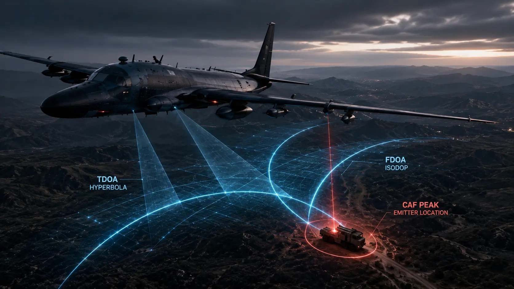
To extract a precise geographic location from a raw signal, computers execute a Cross-Ambiguity Function (CAF). This complex matrix algorithm continuously correlates two physical properties of the intercepted wave. First, it measures the Time Difference of Arrival (TDOA).
If a hostile radar pulse hits the nose antenna of a spy plane exactly one nanosecond before it hits the tail antenna, the system calculates a geometric hyperbola of possible origin points along the ground. However, a single hyperbola only provides a vast line of probability, not a highly accurate point.
To force a strict mathematical intersection, the algorithm simultaneously calculates the Frequency Difference of Arrival (FDOA). Because the aircraft is flying at high speed, the incoming radar wave experiences a microscopic Doppler shift. The frequency compresses slightly at the nose and stretches slightly at the tail.
The FDOA calculation generates a second geometric curve, known as an isodop. The Cross-Ambiguity Function multiplies the TDOA hyperbola and the FDOA isodop together algebraically. The resulting 3D matrix surface produces a single, sharp mathematical peak, immediately plotting the physical location of the hostile radar with sub-meter accuracy.
WHY IT MATTERS NOW
The proliferation of mobile air defense networks fundamentally alters geopolitical deterrence. Adversarial nations mount advanced anti-aircraft missiles on heavy off-road chassis, constantly moving them into dense forests or urban centers to hide from visual satellite photography.
Optical satellites possess severe operational limitations. They cannot see through heavy cloud cover, and their predictable orbital mechanics allow enemies to simply hide their assets when a camera passes overhead. The electromagnetic spectrum offers no such physical refuge.
Defense contractors like L3Harris rely on TDOA-FDOA interferometry to build persistent airborne electronic support networks. Platforms like the RC-135V/W Rivet Joint orbit hundreds of miles away in safe airspace, silently hoovering up thousands of distinct signals per second.
When a mobile missile launcher communicates with its command node via a brief, encrypted VHF radio burst, it exposes itself. The CAF algorithm does not need to decrypt or understand the actual voice communication. It only needs the physical carrier wave to instantly geolocate the truck, stripping away the adversary’s mobility advantage.
This mathematical capability dictates the allocation of multi-billion-dollar defense budgets. By isolating the exact coordinates of an emitter, the intelligence platform feeds targeting data directly to long-range loitering munitions or hypersonic glide vehicles. This process completely closes the kill chain without ever risking a manned fighter jet inside hostile airspace.
WHAT MOST PEOPLE MISS
Military analysts frequently assume that intercepting enemy communications requires extreme physical proximity to the target. They entirely miss the mechanical leverage of cooperative multi-platform interferometry.
An individual aircraft possesses a relatively short physical baseline between its nose and tail antennas, slightly limiting its geolocation resolution. To bypass this hardware limit, modern networks datalink three distinct drones flying miles apart. By combining their intercepted data through a federated Cross-Ambiguity Function, they synthetically create an antenna baseline the size of a small country, generating unprecedented geolocation accuracy.
The hidden incentive driving this engineering lies in spectrum denial. Governments heavily fund passive TDOA architectures because adversaries are engineering low-probability-of-intercept (LPI) radars designed specifically to evade standard detectors. By relying purely on absolute time and frequency mechanics rather than signal amplitude, passive interferometry mathematically traps these stealthy emitters the exact microsecond they broadcast.
THE TRAJECTORY
Next 12–36 Months: The miniaturization of atomic clocks. Low-earth orbit satellite constellations will integrate chip-scale atomic clocks to perfectly synchronize TDOA measurements from space. This architecture will provide continuous, global, real-time geolocation of every emitting military radio on Earth.
Next Five Years: The mass deployment of cognitive signal processing. Machine learning models will autonomously filter out extreme urban electromagnetic static, isolating faint, highly encrypted military signals from the chaotic background noise of civilian cellular networks.
Next Ten Years: The obsolescence of active radar in peer conflict. Major powers will entirely abandon active emissions to survive heavily contested environments. Fighter jets will navigate and target adversaries exclusively using passive multi-static networks, relying on ambient civilian FM radio and television broadcasts to silently illuminate stealth targets.
What Could Go Wrong: Precision GPS denial. The entire CAF matrix relies on nanosecond-perfect timing synchronization between external sensors. If a sophisticated adversary successfully jams or spoofs the GPS timing signals feeding the aircraft, the TDOA calculations immediately fracture, projecting false ghost targets across the intelligence map.
Most Likely Outcome: The Cross-Ambiguity Function will remain the absolute baseline of global signals intelligence. The physical dynamics of time and frequency shifts offer an unavoidable geometric reality, ensuring that any device emitting electromagnetic energy guarantees its own rapid geographic discovery.
KEY TERMS
- Time Difference of Arrival (TDOA): A geolocation method calculating the specific time delay of a single radio signal reaching multiple physically separated receivers.
- Frequency Difference of Arrival (FDOA): A geolocation technique utilizing the Doppler shift of a signal captured by moving sensors to determine emitter velocity and location.
- Cross-Ambiguity Function (CAF): A complex mathematical matrix that multiplies TDOA and FDOA calculations to pinpoint the exact source of an electromagnetic emission.
- Interferometry: The scientific technique of superimposing multiple waves to extract extremely precise measurements from the resulting interference patterns.
- Signals Intelligence (SIGINT): The systematic collection, processing, and analysis of intercepted foreign electronic communications and radar emissions.
SOURCES
- Institute of Electrical and Electronics Engineers (IEEE) — TDOA/FDOA Geolocation and Cross-Ambiguity Function Mathematics
- Defense Advanced Research Projects Agency (DARPA) — Spatial, Temporal and Orientation Information in Contested Environments (STOIC)
- United States Air Force Research Laboratory (AFRL) — Passive Airborne Electronic Support and Multi-Platform Interferometry
- Journal of Electronic Defense — Precision Emitter Location and the Dynamics of Signal Processing