Advertisement
)


A sanctioned oil tanker slips into the ocean under the cover of night. To hide from international authorities, the captain turns off the ship’s mandatory GPS tracking beacon. A massive storm rolls in, covering the sea in dense, impenetrable clouds, rendering standard optical spy satellites completely blind. To the visual world, the multi-million-dollar ship has vanished. But a ship cannot sail blindly through a storm; to avoid crashing into the coastline, the captain must turn on the ship’s marine navigational radar.
Hundreds of miles above in the vacuum of space, a cluster of three microscopic satellites detects a faint, rhythmic burst of electromagnetic energy. Because the radar pulse hits each of the three satellites at slightly different microscopic fractions of a second, onboard algorithms instantly triangulate the signal’s origin. Within milliseconds, the exact coordinates of the “dark” ship are exposed and beamed to a naval command center.
This is the invisible battlefield of Signals Intelligence (SIGINT). For decades, listening to enemy radios and tracking missile radars from outer space was a multi-billion-dollar capability monopolized exclusively by superpowers. Why should you care right now? Because that monopoly is dead. Today, private aerospace startups are launching massive swarms of cheap, commercial listening satellites into Low Earth Orbit. They are mapping the world’s electronic footprint in real-time, completely reshaping how modern militaries and intelligence agencies track illicit trade, unmask GPS spoofing, and expose the hidden hardware of their adversaries.
What is a Signals Intelligence (SIGINT) Constellation?
A Signals Intelligence (SIGINT) constellation is a network of satellites designed to intercept, locate, and analyze radio frequency (RF) emissions from Earth. By flying in synchronized clusters, these satellites use time and frequency calculations to pinpoint the exact geographic origin of radars, communications, and electronic signals, exposing assets that remain invisible to optical cameras.
At a Glance
- Concept: Utilizing swarms of micro-satellites to listen to the electromagnetic spectrum, mapping the exact locations of radio chatter, marine radar, and missile defense systems across the globe.
- Why it matters: It strips away the fog of war. Even if an adversary hides a tank under a camouflage net in the jungle, the tank’s communication radio acts as a glowing beacon to a SIGINT satellite overhead.
- Who uses it: The U.S. National Reconnaissance Office (NRO), NATO defense strategists, and commercial aerospace companies (HawkEye 360, Kleos Space, Spire) selling data to maritime shipping insurers.
- Biggest takeaway: The true value of SIGINT is not just finding a target, but mapping the “Electronic Order of Battle.” By cataloging the exact frequencies an adversary uses, militaries know exactly how to jam those frequencies in a conflict.
In Simple Words
Imagine you are standing in a forest, completely blindfolded. Somewhere in the trees, a police siren turns on. Even though you cannot see the police car, you can instantly point to exactly where it is.
How do you do that? Because the sound of the siren hits your left ear a tiny fraction of a second before it hits your right ear. Your brain unconsciously calculates that microscopic time delay and triangulates the location of the sound.
Orbital SIGINT does this on a planetary scale.
Instead of ears, aerospace engineers use satellites. Instead of sound waves, they listen for radio waves and radar pulses. If an enemy turns on a radar dish on the ground, that radar wave shoots up into space. It hits a cluster of three satellites flying in a triangle formation. Because the satellites are spread apart, the radar wave hits Satellite A slightly before it hits Satellite B and C. High-powered computers calculate that tiny delay and draw a precise line back down to the Earth, pinpointing the exact street corner or patch of ocean where the radar was turned on.
Why This Matters
The commercialization of space has triggered a profound shift in global intelligence gathering: the transition from classified hardware to Data-as-a-Service (DaaS).
For Defense Strategists and Space Investors, the economics of surveillance have permanently changed. Historically, building a SIGINT satellite (like the massive NRO Orion/Mentor platforms) cost over $2 billion, required a massive rocket, and took a decade to deploy. Because they were so expensive, only a few existed, meaning they could only visit a specific geographic target once or twice a day.
Today, commercial space companies launch dozens of cheap, shoebox-sized satellites on commercial rideshare rockets. While these small satellites lack the extreme sensitivity of a $2 billion government asset, their sheer numbers provide “persistent revisit rates.” They can pass over a target every 30 minutes, providing continuous, unclassified data feeds that governments can legally purchase, share with allies, or release to the public media without compromising classified military sources.
Mapping the Electronic Order of Battle (EOB)
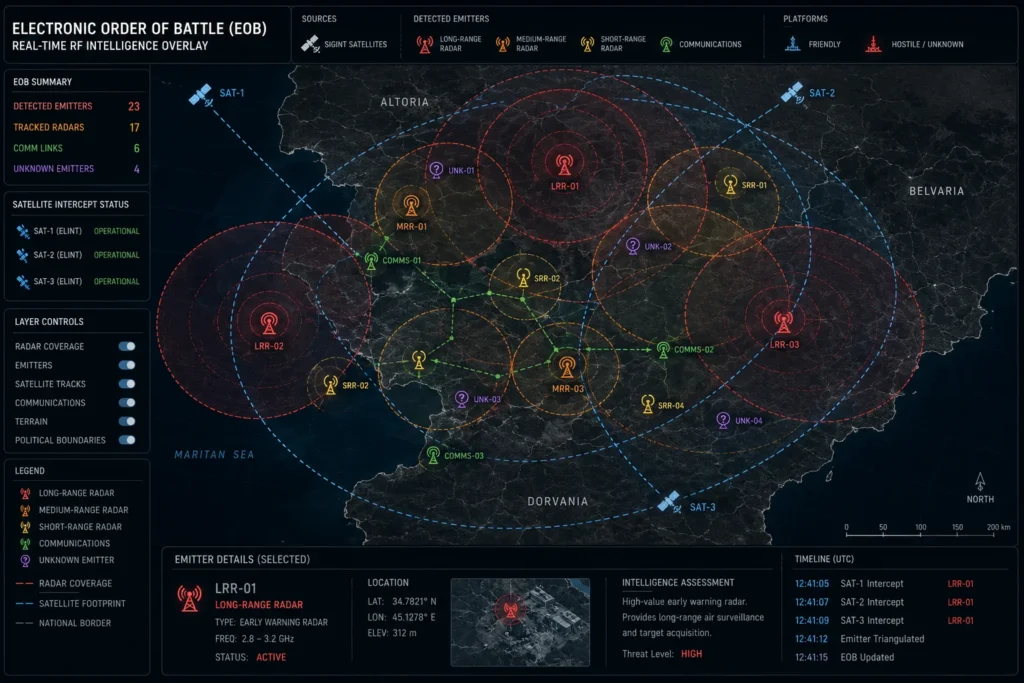
The primary military application of SIGINT constellations is constructing the Electronic Order of Battle (EOB).
In modern warfare, destroying a target physically (kinetic strike) is often secondary to destroying a target electronically. The EOB is a massive database that maps every single electronic emitter an adversary possesses—air traffic control radars, surface-to-air missile targeting arrays, and infantry radio frequencies.
By having commercial SIGINT constellations constantly sweep adversarial borders during peacetime, intelligence agencies capture the unique “fingerprints” of these radars. When a conflict begins, the military’s electronic warfare (EW) aircraft know exactly what frequencies to flood with static (jamming) or exactly what fake signals to broadcast (spoofing) to blind the enemy’s air defenses before the first physical shot is ever fired.
How SIGINT Constellations Geolocate RF Signals
Capturing an invisible radio wave from 500 kilometers in space and tracing it back to a single truck on the ground relies on the absolute physics of the electromagnetic spectrum. Here is the first-principles breakdown of the architecture.
1. The Fundamental Problem: Optical Blindness
Optical spy satellites (IMINT) are limited by physics. They cannot see through clouds, which cover roughly 67% of the Earth at any given moment. They are limited by lighting conditions (night), and they are easily fooled by visual decoys (e.g., painting a piece of plywood to look like a missile launcher).
2. The Insufficiency of Single-Satellite Interception
If a single satellite is flying over the Earth and detects a radio signal, it knows the signal exists, but it struggles to determine exactly where it came from. A single receiver cannot triangulate; it lacks “depth perception” in the electromagnetic spectrum, resulting in a massive, highly inaccurate margin of error.
3. The Core Mechanism: Cluster Formations
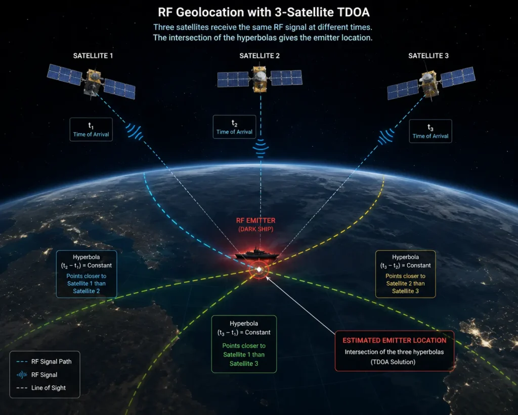
To achieve high-precision geolocation, commercial SIGINT satellites fly in synchronized clusters, typically formations of three or four satellites. They maintain a strict geometric distance from one another (often spaced 50 to 100 kilometers apart) as they orbit the Earth together.
4. Technical Depth: TDOA and FDOA Algorithms
When a ground target emits a signal, the signal travels at the speed of light toward the satellite cluster. The cluster uses two primary mathematical algorithms to locate the source:
- Time Difference of Arrival (TDOA): Because the satellites are spaced apart, the signal hits Satellite 1 a few nanoseconds before it hits Satellite 2. The mathematical formula maps these time differences into intersecting hyperbolas on the Earth’s surface.
Δt = (d1 – d2) / c (Where Δt is the time difference, d is the distance to the satellites, and c is the speed of light). - Frequency Difference of Arrival (FDOA): Because the satellites are moving at 17,500 mph relative to the Earth, the radio wave compresses or stretches depending on the satellite’s exact flight path relative to the emitter (the Doppler effect). Measuring the tiny shifts in the signal’s frequency creates a second set of intersecting lines.
Where the TDOA and FDOA lines cross on the map is the exact location of the target.
5. Real-World Consequences: “Tipping and Cueing”
Once the SIGINT cluster identifies the precise coordinates of a suspicious radar signal hidden under cloud cover, the constellation executes a “Tip and Cue.” The SIGINT satellite automatically sends a digital ping to a Synthetic Aperture Radar (SAR) satellite. The SAR satellite, which can see through clouds using its own active radar beam, immediately reorients to take a high-resolution structural picture of those exact coordinates, confirming the physical identity of the target.
Commercial Applications of Orbital SIGINT Data
The deployment of commercial SIGINT has immediately disrupted illicit supply chains and electronic warfare tactics.
Dark Fleet Maritime Tracking: Global sanctions (such as those placed on Russia or Iran) forbid ships from carrying illicit oil or weapons. To evade blockades, these ships turn off their Automatic Identification System (AIS) transponders, legally “vanishing” from the grid. However, commercial SIGINT constellations track the ship’s X-band marine navigational radar, which the captain must leave on to avoid hitting other ships. The SIGINT cluster geolocates the radar pulse, unmasking the “dark ship” and allowing the Coast Guard to intercept it.
Exposing GPS Spoofing: In combat zones like the Black Sea and Ukraine, military forces use powerful electronic jammers to block or spoof the Global Positioning System (GPS). This causes civilian airplanes and commercial ships to lose navigation or report false locations thousands of miles away. SIGINT constellations monitor the L-band frequencies used by GPS. By triangulating the exact origin of the jamming interference from space, intelligence analysts can pinpoint the physical location of the enemy’s electronic warfare trucks, directing artillery strikes to destroy them.
Search and Rescue (Emergency Beacons): When a ship sinks or a plane crashes in remote oceans, emergency position-indicating radio beacons (EPIRBs) activate. If the GPS coordinates in the beacon fail, SIGINT constellations use TDOA and FDOA to instantly locate the beacon’s raw transmission pulse, drastically shrinking the search radius for rescue helicopters from thousands of square miles down to a few hundred meters.
Economic & Strategic Impact
The transition to unclassified, commercial SIGINT creates an unprecedented Open-Source Intelligence (OSINT) Arbitrage.
Historically, if a U.S. classified spy satellite detected an illegal Chinese fishing fleet operating inside the maritime borders of the Philippines, the U.S. government could not easily share that data. Releasing the coordinates would prove to China exactly how sensitive and precise the classified U.S. satellites were, compromising national security.
Commercial SIGINT bypasses this classification trap. Because companies like HawkEye 360 are private entities operating unclassified hardware, the U.S. government simply buys the data subscription and hands it directly to the Philippine Coast Guard, or publishes it in the New York Times. By utilizing commercial data to “name and shame” bad actors, governments can wage aggressive information warfare without ever risking the exposure of their true, classified military assets.
Advantages
- All-Weather, 24/7 Visibility: Unlike optical cameras, the electromagnetic spectrum is entirely unaffected by cloud cover, atmospheric haze, or the darkness of night.
- Intent Detection: A camera can show you a tank, but SIGINT can intercept the radio chatter from that tank. Knowing what the adversary is communicating provides insight into their operational intent, not just their physical location.
- Defeats Visual Camouflage: A surface-to-air missile battery hidden perfectly under a jungle canopy is completely invisible to a camera, but the moment it turns on its targeting radar, a SIGINT satellite immediately exposes its coordinates.
Limitations
- LPI/LPD Evasion: Advanced militaries actively design Low Probability of Intercept/Low Probability of Detection (LPI/LPD) systems. By using highly directional, tightly focused radar beams (phased arrays) or rapidly changing frequencies 1,000 times a second (frequency-hopping), they can successfully hide their emissions from commercial micro-satellites.
- Data Downlink Latency: A satellite cannot intercept a signal and act on it if it cannot talk to Earth. Commercial satellites in LEO must often wait until they fly over a friendly ground station to download their data. This 30-minute latency means a mobile missile launcher may have driven away by the time the data reaches the military command center.
- Target Silence: The fatal flaw of SIGINT is that it only works if the target is “loud.” If a military unit enforces strict radio silence and turns off all radars (EMCON – Emissions Control), the SIGINT satellite sees absolutely nothing.
Common Misconceptions
Misconception: SIGINT satellites listen to your personal phone calls.
Reality: While highly classified government satellites have the capability to intercept specific cellular communications (COMINT), commercial SIGINT constellations primarily map the metadata—the location, frequency, and power level of a signal—not the encrypted audio content of a phone call.
Misconception: You only need one satellite to track a radio signal.
Reality: A single satellite can tell that a signal exists, but triangulation requires geometry. Without a cluster of at least three satellites to measure the intersecting time delays (TDOA), the geographic margin of error is too massive to be useful for precise military targeting.
Misconception: A radar dish can just point downward to hide from satellites.
Reality: Radar and radio waves do not perfectly form a single line; they emit “side lobes” (scattered energy leaking from the sides of the antenna). Even if a radar is pointed directly at the horizon, enough scattered electromagnetic energy leaks upward into space for highly sensitive orbital antennas to detect.
What Most People Miss
The strategic value of Pattern of Life Analysis.
Intelligence is not just about finding a radar; it is about establishing a baseline of normalcy.
Because commercial SIGINT constellations fly over the same target every few hours, they map the exact RF footprint of a military base for years. They know exactly how many radios are normally used on a Tuesday, and what specific radar tests are run on a Friday. What most people miss is that the true intelligence value occurs when the pattern breaks. If a base that normally emits 50 radio signals a day suddenly goes completely electronically silent at 3:00 AM, that deliberate silence is a glaring anomaly. It indicates that the troops are deploying for a surprise offensive. In SIGINT, the absence of a signal is often just as loud as the signal itself.
Comparison Table
| Feature | Optical Imaging (IMINT) | Synthetic Aperture Radar (SAR) | Signals Intelligence (SIGINT) |
| Primary Sensor | High-resolution visible/IR cameras | Active radar pulses (bounced off Earth) | Passive RF antennas (listening only) |
| Weather Constraint | Blinded by clouds and darkness | Sees through clouds and darkness | Sees through clouds and darkness |
| Target Requirement | Target must be visually exposed | Target must have physical structure | Target must emit an electronic signal |
| Camouflage Defeat | Poor (Easily fooled by tarps/decoys) | Moderate (Can detect metal under foliage) | Excellent (Detects the invisible emissions) |
| Operational Role | Confirming physical damage/layout | Tracking structural movement/ships | Mapping Electronic Order of Battle (EOB) |
Case Study
Situation: Following the invasion of Ukraine, the Black Sea became a highly contested maritime environment. Russian naval vessels frequently disabled their AIS tracking beacons to obscure their operational movements, while simultaneously deploying massive land-based and ship-based GPS jammers to confuse Ukrainian drones and commercial shipping.
Challenge: NATO and Ukrainian intelligence needed to locate the Russian warships and the specific electronic warfare (EW) batteries causing the GPS disruptions, but constant cloud cover over the Black Sea rendered traditional optical satellites largely useless.
Solution (The Commercial SIGINT Deployment): Western intelligence agencies heavily utilized commercial SIGINT data from companies like HawkEye 360. HawkEye’s orbital clusters continuously swept the Black Sea, passively listening for X-band marine navigational radars and the L-band interference signals indicative of GPS spoofing.
Outcome: The satellites mathematically mapped the TDOA signatures of the spoofing interference, pinpointing the exact origin points of the electronic warfare vehicles on the Crimean peninsula. Simultaneously, they geolocated the navigational radars of the “dark” Russian warships moving through the clouded sea. This data was instantly tipped to SAR satellites, which confirmed the targets and fed the coordinates to the Ukrainian military.
Lessons Learned: The conflict served as the definitive crucible for commercial SIGINT. It proved that in heavily jammed, visually obscured combat environments, the electromagnetic spectrum is the most critical intelligence vector. It established that unclassified, commercial RF mapping is now a mandatory requirement for maintaining battlefield situational awareness.
Future Outlook
Next 12–24 Months
The era of Onboard Edge Processing. Currently, satellites must download massive amounts of raw, encrypted radio data to ground stations for supercomputers to run the complex TDOA algorithms. Over the next two years, constellations will increasingly deploy heavy edge-computing processors (like space-hardened NVIDIA GPUs) directly onto the satellites. The cluster will calculate the TDOA math in orbit and beam down only the final GPS coordinate. This will drastically reduce bandwidth costs and cut the tactical latency from 30 minutes down to a few seconds, enabling real-time targeting.
Next 3–5 Years
The scaling of Inter-Satellite Links (ISL). The fatal flaw of LEO constellations is that a satellite cannot communicate if it is not flying over a ground station. By outfitting SIGINT satellites with optical laser cross-links (similar to Starlink’s architecture), satellites will bounce their RF interception data to each other across the vacuum of space, routing the data continuously around the globe. This will eliminate the geographic “blackout zones” and provide governments with a continuous, uninterrupted live feed of global electronic emissions.
Next 10 Years
The Continuous Global EOB Persistence. By the mid-2030s, the cost of manufacturing and launching shoebox-sized SIGINT receivers will drop to near zero. Constellations will expand from dozens of satellites to hundreds, creating an unbroken, overlapping net of RF coverage over the entire planet. The “Electronic Order of Battle” will transition from a static, weekly report into a living, breathing digital twin of the Earth’s electromagnetic spectrum, where every radio, radar, and cell phone tower is permanently mapped and monitored in real-time.
Most Likely Scenario
The traditional distinction between commercial space assets and military spy satellites will completely dissolve. As commercial SIGINT companies prove they can reliably intercept marine radars, GPS spoofers, and military comms at a fraction of the cost of classified government programs, defense agencies will fully outsource their baseline RF mapping. The sky will become an omnipresent, unblinking ear, permanently eliminating the concept of electronic stealth for illicit maritime and military operations.
Key Takeaways
- Signals Intelligence (SIGINT) constellations are networks of satellites that passively listen to radio and radar waves, locating targets that are visually hidden by clouds or camouflage.
- To pinpoint a signal, commercial satellites fly in clusters of three or more, using Time Difference of Arrival (TDOA) to measure the microscopic delays in when a signal hits each satellite.
- SIGINT is the foundation of the Electronic Order of Battle (EOB), allowing militaries to map the exact frequencies of enemy radars so they can be jammed in a conflict.
- Commercial space startups have broken the government monopoly on SIGINT, selling unclassified RF data as a subscription service to track illegal fishing fleets and “dark” sanctioned oil tankers.
- Because SIGINT tracks the invisible electromagnetic spectrum, a target is completely safe if it enforces strict “radio silence”—a severe limitation compared to optical cameras.
- Commercial SIGINT played a critical role in the Ukraine conflict, successfully geolocating Russian electronic warfare trucks by tracking their GPS jamming signals from space.
Glossary
Automatic Identification System (AIS): A mandatory tracking system used on ships that broadcasts their location. Illicit ships frequently turn this off (“going dark”), forcing authorities to use SIGINT to track their marine navigational radars instead.
Electronic Order of Battle (EOB): A comprehensive military database that maps the physical locations and specific frequency signatures of all adversarial electronic emitters (radars, radios, jammers) in a specific region.
Frequency Difference of Arrival (FDOA): A mathematical algorithm used by satellites to geolocate a signal by measuring the Doppler shift (the stretching or compressing of the radio wave) as the satellites move at high speeds relative to the target.
IMINT (Imagery Intelligence): Intelligence gathered via optical cameras or infrared sensors (traditional spy photos). It is highly vulnerable to cloud cover and darkness.
Low Probability of Intercept (LPI): Advanced military radar and radio technology designed explicitly to evade detection by SIGINT satellites, often utilizing rapid frequency-hopping or tightly focused beams.
Time Difference of Arrival (TDOA): The primary trigonometric algorithm used by SIGINT clusters to find a target by measuring the nanosecond delay between a radio wave hitting one satellite versus another.
Frequently Asked Questions
Can SIGINT satellites decrypt secure military radios?
Generally, no. Commercial SIGINT constellations specialize in geolocating the origin of the signal and identifying its frequency and power level (metadata). Breaking advanced military encryption to listen to the actual audio content requires massive, highly classified government supercomputers and is not a commercial service.
Why do they need to fly in a cluster of three?
A single satellite can only tell that a signal hit it; it cannot determine distance or direction accurately. Two satellites can narrow the location down to a line or a broad ring. Three satellites are the geometric minimum required to create intersecting lines (hyperbolas) that definitively pinpoint a specific 2D coordinate on the Earth’s surface.
If the military knows these satellites are overhead, why not just turn off the radars?
They do, a tactic known as Emissions Control (EMCON). However, modern militaries and ships cannot operate effectively while totally blind and deaf. Eventually, a ship must use radar to navigate a narrow strait, or an air defense battery must use radar to scan for incoming missiles, instantly exposing their position.
Can SIGINT satellites detect a single cell phone?
Technically yes, if the conditions are perfect. However, in an urban environment with millions of overlapping cell phone signals, Wi-Fi routers, and television broadcasts, the “noise floor” is too chaotic for commercial satellites to reliably isolate and track a single, low-power civilian device from 500 kilometers away.
Who buys this data besides the military?
Maritime insurance companies buy it to verify that shipping fleets are not traveling into hazardous or sanctioned waters with their AIS transponders turned off. Environmental agencies use it to track illegal, unreported, and unregulated (IUU) fishing fleets operating in protected marine sanctuaries.
Sources
[1] Center for Strategic and International Studies (CSIS): Commercial Space Remote Sensing and its Role in National Security (2025 Analysis)
[2] HawkEye 360: Radio Frequency (RF) Geoanalytics and TDOA/FDOA Constellation Architecture
[3] National Reconnaissance Office (NRO): The Evolution of Commercial SIGINT Integration into the IC
[4] IEEE Aerospace and Electronic Systems: Time Difference of Arrival (TDOA) Localization for Low Earth Orbit Satellite Swarms
[5] Spire Global: Maritime Domain Awareness and RF Interception for Dark Fleet Tracking